File:Latitude and Longitude of the Earth.svg

Size of this PNG preview of this SVG file: 652 × 340 pixels. Other resolutions: 320 × 167 pixels | 640 × 334 pixels | 1,024 × 534 pixels | 1,280 × 667 pixels | 2,560 × 1,335 pixels.
Original file (SVG file, nominally 652 × 340 pixels, file size: 35 KB)
Captions
Captions
Add a one-line explanation of what this file represents
Summary edit
| Description |
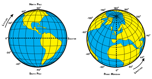
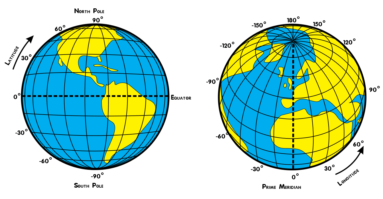
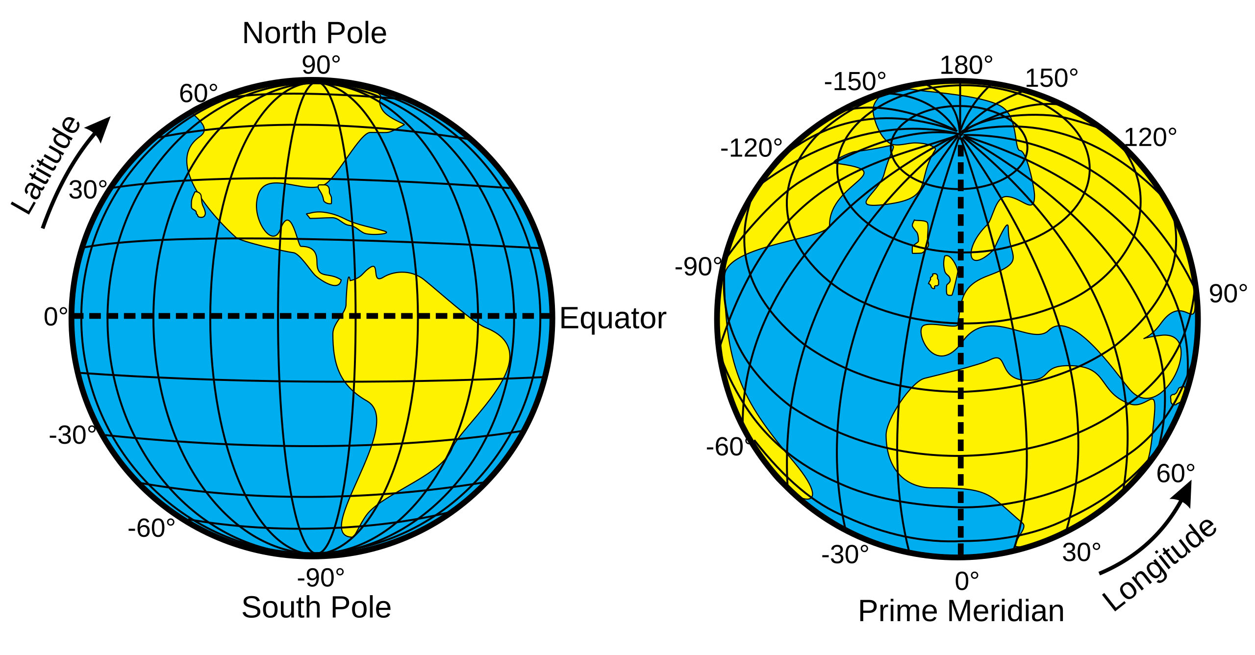
English: Illustration of geographic latitude and longitude of the earth |
| Date | |
| Source | Own work |
| Author | Djexplo |
| Other versions |
[]
|


Licensing edit
I, the copyright holder of this work, hereby publish it under the following license:
| This file is made available under the Creative Commons CC0 1.0 Universal Public Domain Dedication. | |
| The person who associated a work with this deed has dedicated the work to the public domain by waiving all of their rights to the work worldwide under copyright law, including all related and neighboring rights, to the extent allowed by law. You can copy, modify, distribute and perform the work, even for commercial purposes, all without asking permission.
|
File history
Click on a date/time to view the file as it appeared at that time.
| Date/Time | Thumbnail | Dimensions | User | Comment | |
|---|---|---|---|---|---|
| current | 11:23, 13 February 2020 | | 652 × 340 (35 KB) | Omda4wady (talk | contribs) | File uploaded using svgtranslate tool (https://tools.wmflabs.org/svgtranslate/). Added translation for ar. |
| 11:20, 13 February 2020 |  | 652 × 340 (34 KB) | Omda4wady (talk | contribs) | File uploaded using svgtranslate tool (https://tools.wmflabs.org/svgtranslate/). Added translation for ar. | |
| 02:24, 16 September 2019 |  | 652 × 340 (31 KB) | CmplstofB (talk | contribs) | Add Japanese translation and metadata. | |
| 13:13, 27 February 2019 |  | 652 × 340 (39 KB) | Akbarali (talk | contribs) | File uploaded using svgtranslate tool (http://tools.wmflabs.org/svgtranslate/). Added translation for ml. | |
| 14:32, 30 May 2011 |  | 652 × 340 (35 KB) | Djexplo (talk | contribs) |
You cannot overwrite this file.
File usage on Commons
The following 13 pages use this file:
- Geographic diagram
- File:Latitude and Longitude of the Earth-as.svg
- File:Latitude and Longitude of the Earth-dty.svg
- File:Latitude and Longitude of the Earth-gu.svg
- File:Latitude and Longitude of the Earth-hi.svg
- File:Latitude and Longitude of the Earth-mk.svg
- File:Latitude and Longitude of the Earth-ml.svg
- File:Latitude and Longitude of the Earth-ne.svg
- File:Latitude and Longitude of the Earth-ta.svg
- File:Latitude and Longitude of the Earth-te.svg
- File:Latitude and Longitude of the Earth.svg
- File:Latitude and Longitude of the Earth ml.png
- Template:Other versions/Latitude and Longitude of the Earth
File usage on other wikis
The following other wikis use this file:
- Usage on bg.wikipedia.org
- Usage on bs.wikipedia.org
- Usage on bxr.wikipedia.org
- Usage on es.wikibooks.org
- Usage on eu.wikipedia.org
- Usage on fr.wikipedia.org
- Usage on hr.wikipedia.org
- Usage on hu.wikipedia.org
- Usage on ja.wikipedia.org
- Usage on kk.wikipedia.org
- Usage on ko.wikipedia.org
- Usage on pa.wikipedia.org
- Usage on sn.wikipedia.org