File:Laubendorf FrühChristKirch 10 2006.JPG
Size of this preview: 800 × 600 pixels. Other resolutions: 320 × 240 pixels | 640 × 480 pixels | 1,024 × 768 pixels | 1,280 × 960 pixels | 1,600 × 1,200 pixels.
Original file (1,600 × 1,200 pixels, file size: 574 KB, MIME type: image/jpeg)
Captions
Captions
Add a one-line explanation of what this file represents
Summary
edit
| Description |
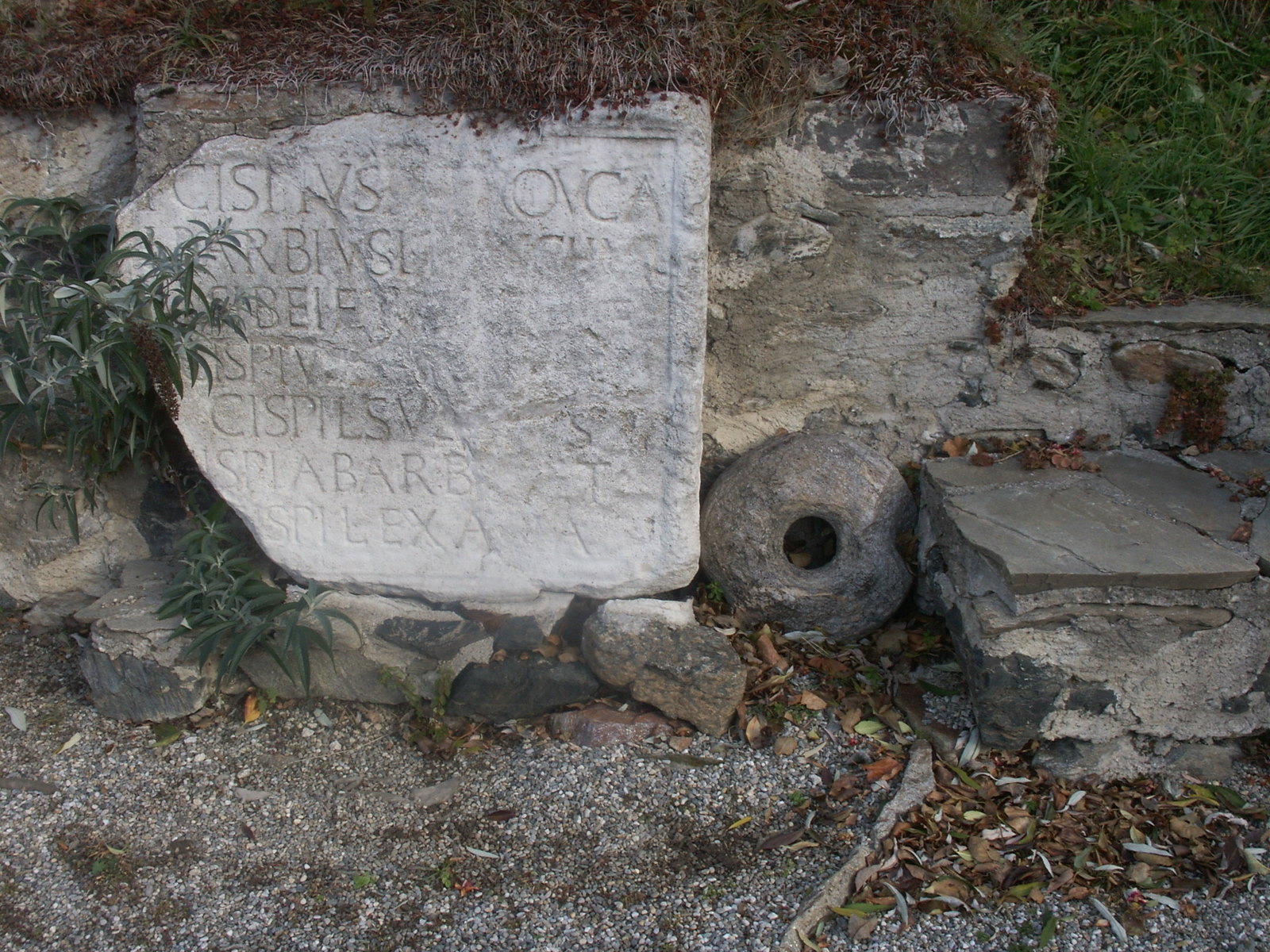
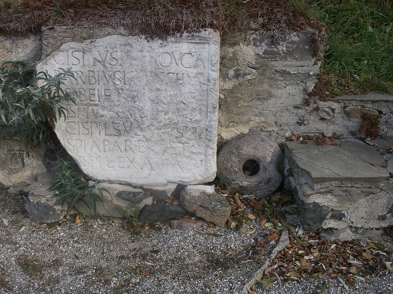
Afrikaans: 'n Voorchristelike grafsteen uit die fondasiemure (waar dit tot einde-2012 gestaan het) van 'n vroeë Christenkerk wat om en by die jaar 600 vernietig is. Dit is geleë te Laubendorf, 'n dorp in die Millstatt-munisipaliteit aan die Millstätterberg, 'n hoë plato bo die Millstättermeer in Kärnten, Oostenryk, Europese Unie. Die voorportaal se altaar, reglynig met die priesterbank geplaas, staan bo 'n nis met oorblyfsels. Dit is met 'n Romeinse marmergrafsteen uit die vroeë keisertyd bedek, waarvan die (voltooide) inskripsie lui: Publius Cispius Publii libertus Trouca / Lucius Barbius Lucii libertus Anchialus / sibei et sueis vivi fecerunt. / Lucius Cispius Lucii Barbii et Publii / Cispii libertus Suadrus / Cispia Barbii et / Cispi liberta Exapia. Die inskripsie is in 1961 voltooi en uitgelê. Al vier hierdie persone dra sowel 'n Keltiese (Trouca, Suadrus, Exapia) as 'n Griekse naam (Anchialus). Hulle was vrygelatenes van twee bekende Italiaanse besigheidsfamilies, die Barbii en Cispii. Albei het onder die groot handelshere uit Aquileia getel, en het belangrike sakebelange (mynbou en metaalhandel) in Noricum besit. Die eietydse formulering op die grafsteen kan na ongeveer 30 v.C. terugdateer word. Die vermelde name is moontlik dié van handelsverteenwoordigers, wat deur neerslae van granaatminerale na die Millstätter-alpe gelok is. Die oorspronklike staanplek van die inskripsie is tans egter nie meer bepaalbaar nie, en omstandighede suggereer dat dit eers in die laat-antieke tyd na Laubendorf gebring is. Aanduidings van 'n voorafgaande nedersetting te Laubendorf, wat minstens tot in die 1ste eeu v.C. teruggevoer kan word, was naamlik die ouer boureste onder die kerkvloer, wat nie voldoende bestudeer is nie. Die aanliggende suid- en noordkamers is ook nie opgegrawe nie. Die gemeenskap van Millstatt am See het nie op bewaring van die argeologiese terrein aangedring nie, en dit is einde-2012, na 55 jaar, weer opgevul. Die steen staan nou by die oprit na 'n skuur, suid van die voormalige plek. Deutsch: Grabplatte bei den Grundmauern (Standort bis Ende 2012) einer um 600 zerstörten frühchristlichen Kirche in Laubendorf, einem Dorf in der Gemeinde Millstatt am Millstätter Berg (Hochplateau) über dem Millstättersee in Kärnten / Österreich / Europäische Union. Der Altar in der vorderen Apsis, zentral zur Priesterbank ausgerichtet, liegt über einer Reliquiengrube. Diese war mit einem frühkaiserzeitlicher Grabstein aus Marmor abgedeckt. Dessen Inschrift lautet: P(ublius) Cispius P(ublii) l(ibertus) Trouca / L(ucius) Barbius L(ucii) l(ibertus) [A]nchial(us) / sibei et [sueis] v[ivi] f(ecerunt). / L(ucius) Cispiu[s L(ucii) Barbii et Publii] / Cispi(i) l(ibertus) Su[adru]s / [C]ispia Barb[i(i) e]t / Cisp(i) l(iberta) Exa[pi]a.[1] Die Inschrift wurde 1961 ergänzt und interpretiert. Die vier genannten Personen tragen sowohl keltische (Trouca, Suadrus, Exapia) als auch einen griechischen Namen (Anchialus). Sie sind Freigelassene (liberti) der bekannten italischen Unternehmerfamilien der Barbii und Cispii, die beide zu den großen Handelsherren aus Aquileia gehörten und in Noricum wichtige Handelsverbindungen (Bergbau, Handel mit Metallen) besaßen. Der Stein wurde aufgrund der altertümlichen Formulierungen in die Zeit um 30 v. Chr. datiert. Die Genannten waren möglicherweise Handelsvertreter, die sich für die Granatvorkommen der Millstätter Alpe interessierten. Der ursprüngliche Aufstellungsort der Inschrift ist nicht mehr eruierbar. Unter Umständen wurde er erst in der Spätantike nach Laubendorf gebracht. Möglicherweise gab es in Laubendorf eine Vorgängersiedlung, die zumindest bis in das 1. Jahrhundert n. Chr. zurückreichte. Hinweise darauf wären ältere Baureste unter dem Kirchenboden, die nicht ausreichend untersucht wurden. Die südlichen und nördlichen Nebenräume sind ebenfalls nicht ergraben. Das Bodendenkmal wurde Ende 2012 zugeschüttet. Der Stein liegt nun bei der Auffahrt einer Scheune, südlich des früheren Platzes.
English: Roman tomb slab in the ruin of an early christian church, destroyed around 600 in Laubendorf near Lake Millstatt (Millstätter See), district Spittal an der Drau in Carinthia / Austria / EU. The Paleochristian churche in Carinthia was filled in again after 55 years. The community Millstatt am See has not fought for the preservation. The grave stone now lies on the southern edge of the property at the driveway to the barn. |
|
| Date | ||
| Source | Own work | |
| Author | Joadl | |
| Permission (Reusing this file) |
|
| Camera location | | View this and other nearby images on: OpenStreetMap |
|---|
Licensing
edit
I, the copyright holder of this work, hereby publish it under the following licenses:

|
Permission is granted to copy, distribute and/or modify this document under the terms of the GNU Free Documentation License, Version 1.2 or any later version published by the Free Software Foundation; with no Invariant Sections, no Front-Cover Texts, and no Back-Cover Texts. A copy of the license is included in the section entitled GNU Free Documentation License. |
This file is licensed under the Creative Commons Attribution-Share Alike 3.0 Austria license.
- You are free:
- to share – to copy, distribute and transmit the work
- to remix – to adapt the work
- Under the following conditions:
- attribution – You must give appropriate credit, provide a link to the license, and indicate if changes were made. You may do so in any reasonable manner, but not in any way that suggests the licensor endorses you or your use.
- share alike – If you remix, transform, or build upon the material, you must distribute your contributions under the same or compatible license as the original.

You may select the license of your choice.
- ↑ Laubendorf In: Christian Gugl: Das Umland Teurnias vom 2. Jahrhundert v. Chr. bis ins 1. Jahrhundert n. Chr. — Eine Studie zur Siedlungskontinuität von der Latène- zur Römerzeit im oberen Drautal, E-Publikation, 2000.
File history
Click on a date/time to view the file as it appeared at that time.
| Date/Time | Thumbnail | Dimensions | User | Comment | |
|---|---|---|---|---|---|
| current | 21:11, 6 March 2007 | | 1,600 × 1,200 (574 KB) | JOADL (talk | contribs) | == Summary == {{Information |Description = [de] Grabplatte bei den Grundmauern einer um 600 zerstörten frühchristlichen Kirche in Laubendorf, einem Dorf in der Gemeinde Millstatt am Millstätter Berg (Hochplat |
You cannot overwrite this file.
File usage on Commons
The following 2 pages use this file:
File usage on other wikis
The following other wikis use this file:
- Usage on de.wikipedia.org