File:Laurie island map-fr.svg

Size of this PNG preview of this SVG file: 800 × 420 pixels. Other resolutions: 320 × 168 pixels | 640 × 336 pixels | 1,024 × 537 pixels | 1,280 × 672 pixels | 2,560 × 1,343 pixels | 867 × 455 pixels.
Original file (SVG file, nominally 867 × 455 pixels, file size: 134 KB)
Captions
Captions
Add a one-line explanation of what this file represents
Summary
edit
| Description |
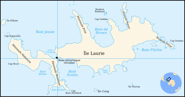
Français : Carte de l'île Laurie dans l'archipel des Orcades du sud près de l'antarctique : french version
English: Map of Laurie island in South Orkney Islands near Antartic : french version |
| Date | |
| Source | own work made with Inkscape from a map made in 1903 by a Scottish National Antarctic Expedition printed by J G Bartholomew at the Edinburgh Geographical Institute and published in Volume 2 (1907) of the "Scientific Results of the Voyage of S Y Scotia 1902-1904". You can found it at this adress. |
| Author | Pinpin |
| Other versions | In English: File:Laurie island map-en.svg |
This W3C-unspecified vector image was created with Inkscape .

|
This SVG file contains embedded text that can be translated into your language, using any capable SVG editor, text editor or the SVG Translate tool. For more information see: About translating SVG files. |
Licensing
edit
I, the copyright holder of this work, hereby publish it under the following licenses:

|
Permission is granted to copy, distribute and/or modify this document under the terms of the GNU Free Documentation License, Version 1.2 or any later version published by the Free Software Foundation; with no Invariant Sections, no Front-Cover Texts, and no Back-Cover Texts. A copy of the license is included in the section entitled GNU Free Documentation License. |
| This file is licensed under the Creative Commons Attribution-Share Alike 3.0 Unported license. | ||
| ||
| This licensing tag was added to this file as part of the GFDL licensing update. |
This file is licensed under the Creative Commons Attribution-Share Alike 2.5 Generic, 2.0 Generic and 1.0 Generic license.
- You are free:
- to share – to copy, distribute and transmit the work
- to remix – to adapt the work
- Under the following conditions:
- attribution – You must give appropriate credit, provide a link to the license, and indicate if changes were made. You may do so in any reasonable manner, but not in any way that suggests the licensor endorses you or your use.
- share alike – If you remix, transform, or build upon the material, you must distribute your contributions under the same or compatible license as the original.
You may select the license of your choice.
File history
Click on a date/time to view the file as it appeared at that time.
| Date/Time | Thumbnail | Dimensions | User | Comment | |
|---|---|---|---|---|---|
| current | 09:37, 7 December 2007 | | 867 × 455 (134 KB) | Pinpin (talk | contribs) | {{Information |Description={{fr|Carte de l'île Laurie dans l'archipel des Orcades du sud près de l'antarctique : french version}} {{en|Map of Laurie island in South Orkney Islands near Antartic : french version}} |Source=own work made with Inkscape from |
You cannot overwrite this file.
File usage on Commons
There are no pages that use this file.
File usage on other wikis
The following other wikis use this file:
- Usage on ast.wikipedia.org
- Usage on da.wikipedia.org
- Usage on de.wikipedia.org
- Usage on es.wikipedia.org
- Usage on fr.wikipedia.org
- Usage on it.wikipedia.org
- Usage on nn.wikipedia.org
- Usage on no.wikipedia.org