File:Lelylijn hypothetisch tracé.svg

Size of this PNG preview of this SVG file: 549 × 600 pixels. Other resolutions: 220 × 240 pixels | 439 × 480 pixels | 703 × 768 pixels | 937 × 1,024 pixels | 1,875 × 2,048 pixels | 908 × 992 pixels.
Original file (SVG file, nominally 908 × 992 pixels, file size: 2.25 MB)
Captions
Captions
Add a one-line explanation of what this file represents
Summary edit
| Description |
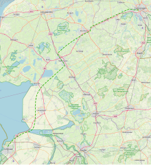
Nederlands: Een hypothetisch tracé voor de in 2018 voorgestelde Lelylijn, een hogesnelheidslijn van Lelystad via Emmeloord, Heerenveen en Drachten naar Groningen-stad. |
| Date | |
| Source | OpenStreetMap |
| Author | © OpenStreetMap contributors, Nederlandse Leeuw |
| Other versions |
File:Lelylijn hypothetische tracés Potentieonderzoek 2020.svg |
Licensing edit
| This work contains information from OpenStreetMap, which is made available under the Open Database License (ODbL).
The ODbL does not require any particular license for maps produced from ODbL data. Prior to 1 August 2020, map tiles produced by the OpenStreetMap Foundation were licensed under the CC-BY-SA-2.0 license. Maps produced by other people may be subject to other licences. |
File history
Click on a date/time to view the file as it appeared at that time.
| Date/Time | Thumbnail | Dimensions | User | Comment | |
|---|---|---|---|---|---|
| current | 06:08, 25 June 2020 | | 908 × 992 (2.25 MB) | Nederlandse Leeuw (talk | contribs) | Uploaded own work with UploadWizard |
You cannot overwrite this file.
File usage on Commons
The following 3 pages use this file: