File:Les 26 provinces de la RDC vue du ciel.jpg

Size of this preview: 600 × 600 pixels. Other resolutions: 240 × 240 pixels | 480 × 480 pixels | 734 × 734 pixels.
Original file (734 × 734 pixels, file size: 135 KB, MIME type: image/jpeg)
Captions
Captions
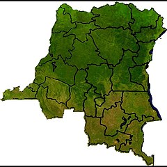
Satellite view of the 26 provinces of the DRC.
Summary edit
| Description |
Français : La carte de la RDC
English: The DRC map
Lingála : Karte ya Kongo Ekolo ya bokonzi ya bana-mboka—K.E.B.B (République Démocratique du Congo —RDC) |
| Date | |
| Source | Own work |
| Author | Roger Inonga |
Licensing edit
I, the copyright holder of this work, hereby publish it under the following license:
This file is licensed under the Creative Commons Attribution-Share Alike 4.0 International license.
- You are free:
- to share – to copy, distribute and transmit the work
- to remix – to adapt the work
- Under the following conditions:
- attribution – You must give appropriate credit, provide a link to the license, and indicate if changes were made. You may do so in any reasonable manner, but not in any way that suggests the licensor endorses you or your use.
- share alike – If you remix, transform, or build upon the material, you must distribute your contributions under the same or compatible license as the original.
File history
Click on a date/time to view the file as it appeared at that time.
| Date/Time | Thumbnail | Dimensions | User | Comment | |
|---|---|---|---|---|---|
| current | 19:28, 22 November 2020 | | 734 × 734 (135 KB) | Roger Inonga (talk | contribs) | J'ai encore bien fixées les provinces |
| 10:53, 18 December 2019 |  | 1,080 × 1,072 (175 KB) | Roger Inonga (talk | contribs) | User created page with UploadWizard |
You cannot overwrite this file.
File usage on Commons
There are no pages that use this file.