File:Les Isles Britanniques - ou sont le Rme d'Angleterre tire ́de Sped celuy d'Ecosse tire ́de Th Pont &c et celuy d'Irlande tire de (MAPS 103).jpg

Original file (7,376 × 5,726 pixels, file size: 9.85 MB, MIME type: image/jpeg)
Captions
Captions
|
This image was automatically transferred from the collections of the University of Washington. While certainly the majority of metadata in their database is correct, it is not necessarily written by individuals who are expert on the material they are describing. Such images often have incorrect dates, locations, or other information. If you can verify that this information is correct, or correct it if it isn't, please do so and remove this template. Also, if you are correcting information, please also let the library know so that they can update the metadata on their site. You can contact UW LIBRARIES MSCUA at photos |
Summary
edit| Title |
English: Les Isles Britanniques : ou sont le Rme. d'Angleterre tire ́de Sped celuy d'Ecosse tire ́de Th. Pont &c. et celuy d'Irlande tire de Petti Le tout rectifie ́par diverses observations |
|||||||||||||||||||||||
| Description |
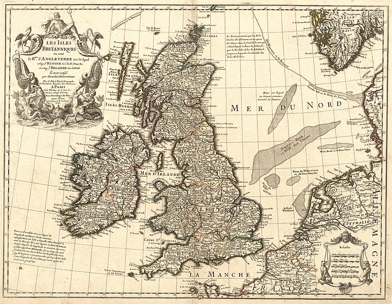
English: Copper engraving handcolored with watercolor. Paper contains two watermarks. Outline color. Relief shown pictorially. Printed in cartouche in top right corner: " Les Isles Britanniques ou sont le Rme. d'Angleterre tire de Sped celuy d'Ecosse tire de Th. Pont etc. et celuy d'Irlande tire de Petti Le tout rectifié par diverses Observations Par G. De L'Isle Geographe, de l'Academie Royale des Sciences. A Paris Chéz l'Auteur sur le Quai de l'Horloge a l'Aigle d'Or Avec Privilege du Roy pour 20. Ans. Gravé par J.B. Liébaux 1702." Printed below title cartouche on right: "C. Simonneau Inv. et. Sculp." Printed in lower left corner off southwest coast of Ireland: "Dans ce Parallele et a un degree de longitude quelques Cartes marines representent une Isle a lacquelle ells donnent le nom de Brasil. Et a 46. degréz et demi de latitude et 356. degréz de longitude ou environ une autre qu'elles appellant Assmanda. Je ne Scay Sur quell fondement ces deux Isles ont été places mais j'ay de la peine a me persuader qu'il y ait des Isles si peu éloignées de nos Cotes qui nous ayent été inconnues jusqu'icy." Printed northeast of Scotland in North Sea: "Le Borneur nommé par les Hollandois De Kimmen est un espece de Coteau dans le fond de la mer qui s'étend depués le Banc de Jutlande par le Nord des Isles de Schetland, jusques a la partie Occidentale des Isles Hebrides." Printed in lower right corner is a scale comparing English miles, Scottish miles, Irish miles, French leagues and marine leagues. Written in ink in top right corner: "No. 24." Depicts England, Wales, Ireland and Scotland. Also includes parts of France, Germany, Denmark, Norway, the North Sea and several shoals in the North Sea including Doggers Bank. Of note, the English Channel is shown under its French name, "La Manche." England has been divided into various provinces by cardinal direction as has Scotland. Ireland has been divided into four major provinces labeled as Mounster, Leinster, Connaught and Ulster. North of the British Isles is a submerged continental edge labeled as "De Kimen ou le Borneur" stretching from the Jutland Bank off of the coast of Denmark through the Shetland Islands and to the north of the Hebrides. Shows detailed river and place names. The title cartouche is decorated with the God of the Sea "Neptune", two large sea birds, fishing nets full of fish, mermen and two sea-horses. Surrounding the scale is an illustration of two chained dogs. Scale: c.a. 1:2,550,000.Guillaume de L'Isle (1675-1726) was a cartographer and the Premier Geographer to the King in France beginning in 1718. His family played a significant part in the world of French cartography in the eighteenth century. At age 9, he drew his first map and at age 27 he became a member of the Académie Royale des Sciences. He studied under Jacques Cassini, acquiring knowledge in both mathematics and astronomy. Due to his academic background and his "critical approach to the maps of his predecessors," he became known as the first "scientific cartographer" (Moreland and Bannister, 132). Among his works are "Globe, map of the world and the four continents" (1700), "Atlas de Géographie" (1700-12), "Mississippi" (1701), "Carte du Mexique et de la Floride…" (c.a. 1703), "Carte de la Louisiane et du Mississippi" (1718) and posthumously, "Atlas Noveau" (1730 and later). Following his death, his widow took up the business with a partner, Philippe Buache (Tooley 395; Moreland and Bannister, 131-2). This particular map was, according to the title, based on maps of England and Wales by John Speed, maps of Scotland by Pont and maps of Ireland by Petty. De L'Isle created the map early in his career and according to Shirley, it is indicative of the "high standard" of de L'Isle's mapmaking. The map contains a note just southwest of Ireland stating de L'Isle's doubt in the existence of the imaginary islands of Brasil and Assmanda shown on previous maps. Shirley notes the beauty of the cartouche drawn by Charles Simmoneau and the accuracy of the map for this time period. The map was copied by many other cartographers including Pierre, Moriter and R. and J. Ottens. This version of the map is the fourth of ten known states of the map, most likely printed after January 1708 as indicated by the address in the title cartouche (Shirley, 50). Source(s): David Rumsey Cartography Associates. "David Rumsey Collection: Les Isles Britanniques ou sont le Rme. d'Angleterre tire de Sped, celu" Accessed 3 Feb 2009. Moreland, Carl and David Bannister. "Antique Maps: A Collector's Handbook." New York: Longman Group, Ltd., 1983. Shirley, Rodney W. "Printed Maps of the British Isles 1650 - 1750." Hertfordshire: Map Collector Publication Ltd. and the British Library, 1988. Tooley, Ronald Vere. "Tooley's Dictionary of Mapmakers." Hertfordshire: Map Collector Publications Limited, 1979.
|
|||||||||||||||||||||||
| Publisher | L'Isle, Guillaume de 1675-1726 | |||||||||||||||||||||||
| Digital ID Number | MAP159 | |||||||||||||||||||||||
| Condition | Browning around edges. Has binder's guard. | |||||||||||||||||||||||
| Date | between 1702 and 1708 | |||||||||||||||||||||||
| Source |
English: World and Regional Maps Collection |
|||||||||||||||||||||||
| Creator |
English: Liebaux, Jean Baptiste English: Charles Simonneau |
|||||||||||||||||||||||
| Permission (Reusing this file) |
|
|||||||||||||||||||||||
| Geotemporal data | ||||||||||||||||||||||||
| Map location | British Isles | |||||||||||||||||||||||
| Georeferencing | If inappropriate please set warp_status = skip to hide. | |||||||||||||||||||||||
| Place of publication | Paris | |||||||||||||||||||||||
| Archival data | ||||||||||||||||||||||||
| Collection |
|
|||||||||||||||||||||||
| Accession number | ||||||||||||||||||||||||
| Dimensions | height: 47 cm (18.5 in); width: 60 cm (23.6 in) | |||||||||||||||||||||||


.jpg&action=edit§ion=1)
File history
Click on a date/time to view the file as it appeared at that time.
| Date/Time | Thumbnail | Dimensions | User | Comment | |
|---|---|---|---|---|---|
| current | 05:22, 8 July 2022 | | 7,376 × 5,726 (9.85 MB) | BMacZeroBot (talk | contribs) | Batch upload (Commons:Batch uploading/University of Washington Digital Collections) |
You cannot overwrite this file.
File usage on Commons
There are no pages that use this file.
.jpg&oldid=818127153)