File:Les Micmacs (multilingual).svg

Size of this PNG preview of this SVG file: 800 × 499 pixels. Other resolutions: 320 × 200 pixels | 640 × 399 pixels | 1,024 × 639 pixels | 1,280 × 799 pixels | 2,560 × 1,597 pixels | 3,387 × 2,113 pixels.
Original file (SVG file, nominally 3,387 × 2,113 pixels, file size: 455 KB)
Captions
Captions
Add a one-line explanation of what this file represents
Summary
edit| Description |
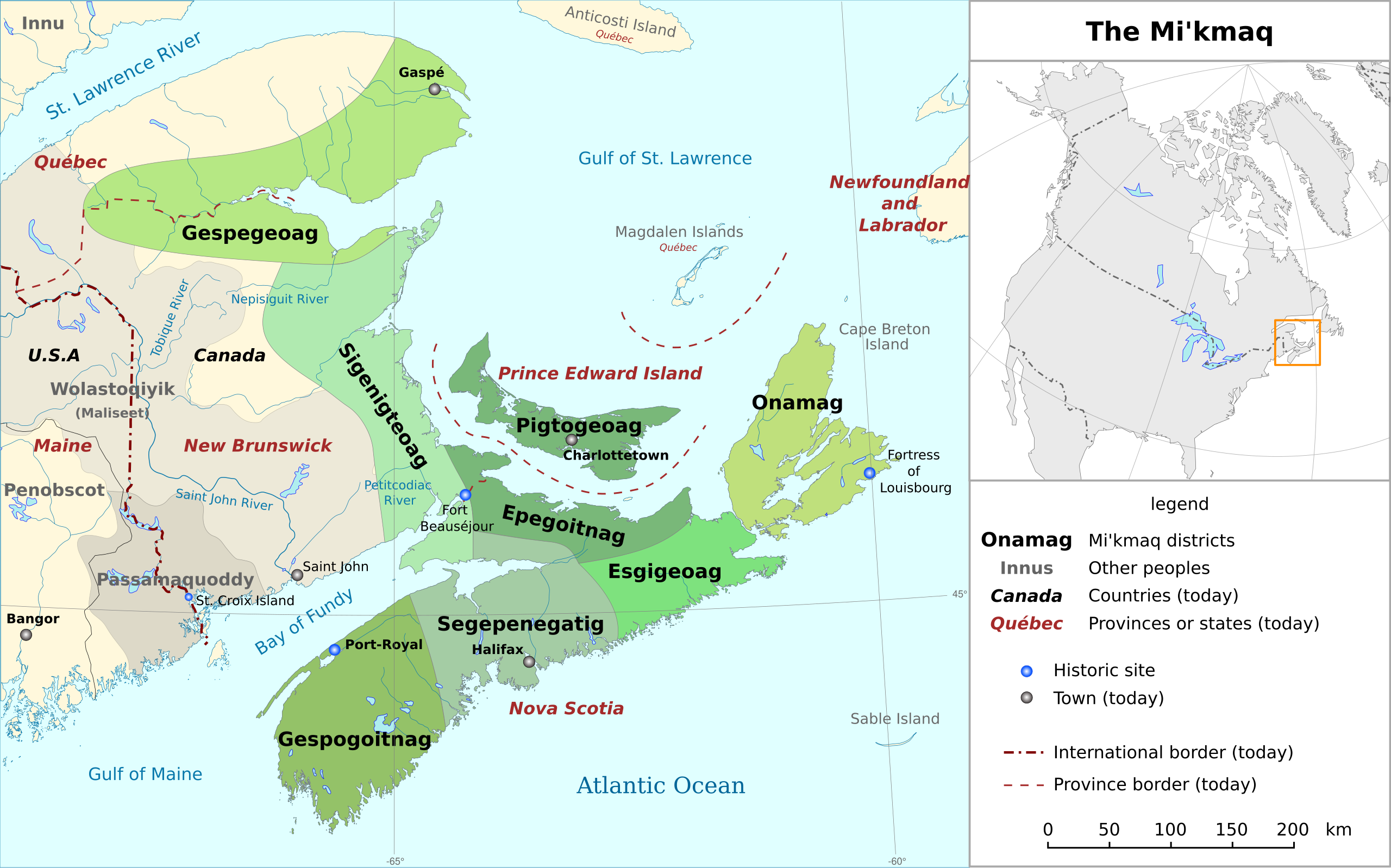
Français : Carte des territoires des Micmacs (multilingue) : ca, en, es, de, fr, it, nl
English: Mi'kmaq territories map (multilingual) : ca, en, es, de, fr, it, nl
Español: Mapa de territorios Micmac (multilingual) : ca, en, es, de, fr, it, nl
Deutsch: Mi'kmaq Territorien Karte (multilingual) : ca, en, es, de, fr, it, nl
Italiano: Insediamenti precedenti dei sette gruppi tribali Mi'kmaq (multilingual) : ca, en, es, de, fr, it, nl
Català: Área antiga dels set grups dels micmac (multilingual) : ca, en, es, de, fr, it, nl |
| Date | |
| Source | Own work à partir des images bitmap (Mikmaq) |
| Author | Michka B |
| Other versions |
|
| SVG development | This diagram is translated using SVG switch elements: all translations are stored in the same file. |


.svg&action=edit§ion=1)
Licensing
edit.svg&action=edit§ion=2)
I, the copyright holder of this work, hereby publish it under the following license:
This file is licensed under the Creative Commons Attribution-Share Alike 4.0 International license.
- You are free:
- to share – to copy, distribute and transmit the work
- to remix – to adapt the work
- Under the following conditions:
- attribution – You must give appropriate credit, provide a link to the license, and indicate if changes were made. You may do so in any reasonable manner, but not in any way that suggests the licensor endorses you or your use.
- share alike – If you remix, transform, or build upon the material, you must distribute your contributions under the same or compatible license as the original.
File history
Click on a date/time to view the file as it appeared at that time.
| Date/Time | Thumbnail | Dimensions | User | Comment | |
|---|---|---|---|---|---|
| current | 12:18, 14 January 2024 | | 3,387 × 2,113 (455 KB) | NordNordWest (talk | contribs) | some German corrections |
| 15:43, 25 March 2018 |  | 3,387 × 2,113 (455 KB) | Michka B (talk | contribs) | implémentation : ca, it Québec mis dans chaque langue car certaines ne mettent pas l'accent. | |
| 09:11, 25 March 2018 |  | 3,387 × 2,113 (442 KB) | Michka B (talk | contribs) | Correction : systemLanguage="es" Implémentation nl | |
| 13:19, 14 March 2018 |  | 3,387 × 2,113 (438 KB) | Michka B (talk | contribs) | Utilisation de la police de caractère Dejavu. | |
| 17:29, 11 March 2018 |  | 3,387 × 2,113 (438 KB) | Michka B (talk | contribs) | Correction de l'erreur de visualisation | |
| 17:25, 11 March 2018 |  | 3,387 × 2,113 (438 KB) | Michka B (talk | contribs) | User created page with UploadWizard |
You cannot overwrite this file.
File usage on Commons
The following page uses this file:
File usage on other wikis
The following other wikis use this file:
- Usage on ar.wikipedia.org
- Usage on ca.wikipedia.org
- Usage on de.wikipedia.org
- Usage on en.wikipedia.org
- Usage on es.wikipedia.org
- Usage on et.wikipedia.org
- Usage on frr.wikipedia.org
- Usage on fr.wikipedia.org
- Usage on gd.wikipedia.org
- Usage on lfn.wikipedia.org
- Usage on nn.wikipedia.org
- Usage on no.wikipedia.org
- Usage on sr.wikipedia.org
- Usage on ur.wikipedia.org
- Usage on www.wikidata.org
- Usage on zh.wikipedia.org
.svg&oldid=841442308)