File:Levant 830.png

No higher resolution available.
Levant_830.png (544 × 593 pixels, file size: 26 KB, MIME type: image/png)
Captions
Captions
Add a one-line explanation of what this file represents

|
File:Levant 830.svg is a vector version of this file. It should be used in place of this PNG file when not inferior.
File:Levant 830.png → File:Levant 830.svg
For more information, see Help:SVG. |
 |
Summary edit
| Description |
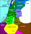
Map of the en:Levant, c. 830 BCE. Kingdom of Judah
Kingdom of Israel
Philistine city-states
Phoenician states
Kingdom of Ammon
Kingdom of Edom
Kingdom of Aram-Damascus
Aramean tribes
Arubu tribes
Nabatu tribes
Assyrian Empire
Kingdom of Moab |
||||||||
| Source | Briangotts | ||||||||
| Author | User Briangotts on en.wikipedia | ||||||||
| Permission (Reusing this file) |
Briangotts at the English-language Wikipedia, the copyright holder of this work, hereby publishes it under the following license:
|
||||||||
| Other versions |
Originally from en.wikipedia; description page is (was) here * 13:48, 9 August 2006 [[:en:User:Briangotts|Briangotts]] 544×593 (26,114 bytes) <span class="comment">(Map of the [[:en:Levant]], c. 830 BCE. [[:en:Category:Historical maps by User:Briangotts]] )</span> |

Other versions edit
-
 Captions in Dutch

File history
Click on a date/time to view the file as it appeared at that time.
| Date/Time | Thumbnail | Dimensions | User | Comment | |
|---|---|---|---|---|---|
| current | 21:36, 12 September 2006 | | 544 × 593 (26 KB) | Mch~commonswiki (talk | contribs) | Map of the Levant, c. 830 BCE. From en-wiki |
You cannot overwrite this file.
File usage on Commons
The following 6 pages use this file:
File usage on other wikis
The following other wikis use this file:
- Usage on ca.wikipedia.org
- Usage on da.wikipedia.org
- Usage on en.wikipedia.org
- Usage on fi.wikipedia.org
- Usage on hak.wikipedia.org
- Usage on is.wikipedia.org
- Usage on lv.wikipedia.org
- Usage on www.mediawiki.org
- Usage on oc.wikipedia.org
- Usage on pl.wikipedia.org
- Usage on sq.wikipedia.org
- Usage on sv.wikipedia.org
- Usage on ta.wikipedia.org
- Usage on tr.wikipedia.org
- Usage on zh.wikipedia.org