File:Li-Wu Hydroelectric Development Projects Dam Location Map.png

Size of this preview: 800 × 450 pixels. Other resolutions: 320 × 180 pixels | 640 × 360 pixels | 1,024 × 576 pixels | 1,280 × 720 pixels | 2,000 × 1,125 pixels.
Original file (2,000 × 1,125 pixels, file size: 231 KB, MIME type: image/png)
Captions
Captions
Add a one-line explanation of what this file represents
Summary edit
| Description |
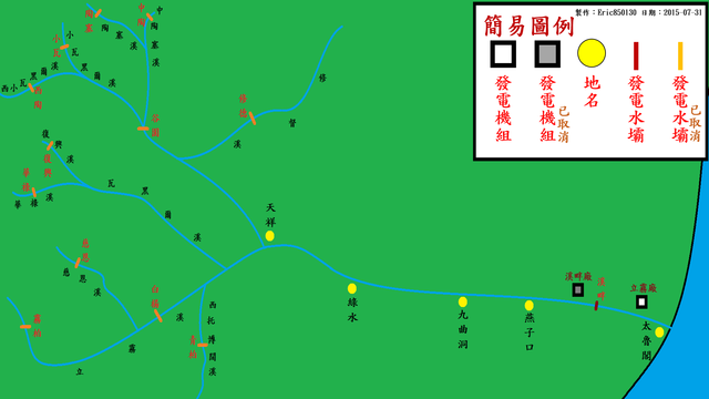
中文(臺灣):於1970年代花蓮立霧水力開發計劃中已動工的溪畔水力發電計劃與谷園水力發電計劃水壩預定位置圖
參考自張瑞津. 《立霧溪流域人工壩堤對地形、地質及地理景觀之影響》. 中華民國(臺灣): 內政部營建署太魯閣國家公園管理處. 2000年(民國89年)11月30日。 English: 1970s Li-Wu Hydroelectric Development Projects Dam Location Map |
| Date | |
| Source | Own work |
| Author | Eric850130 |
Licensing edit
I, the copyright holder of this work, hereby publish it under the following license:
This file is licensed under the Creative Commons Attribution-Share Alike 4.0 International license.
- You are free:
- to share – to copy, distribute and transmit the work
- to remix – to adapt the work
- Under the following conditions:
- attribution – You must give appropriate credit, provide a link to the license, and indicate if changes were made. You may do so in any reasonable manner, but not in any way that suggests the licensor endorses you or your use.
- share alike – If you remix, transform, or build upon the material, you must distribute your contributions under the same or compatible license as the original.
File history
Click on a date/time to view the file as it appeared at that time.
| Date/Time | Thumbnail | Dimensions | User | Comment | |
|---|---|---|---|---|---|
| current | 12:13, 27 September 2016 | | 2,000 × 1,125 (231 KB) | Cmdrjameson (talk | contribs) | Compressed with pngout. Reduced by 86kB (27% decrease). |
| 07:48, 31 July 2015 |  | 2,000 × 1,125 (318 KB) | Matt8830 (talk | contribs) | User created page with UploadWizard |
You cannot overwrite this file.
File usage on Commons
There are no pages that use this file.
File usage on other wikis
The following other wikis use this file:
- Usage on zh.wikipedia.org