File:Liancourt Rocks Map ka.svg

Size of this PNG preview of this SVG file: 657 × 600 pixels. Other resolutions: 263 × 240 pixels | 526 × 480 pixels | 841 × 768 pixels | 1,121 × 1,024 pixels | 2,243 × 2,048 pixels | 748 × 683 pixels.
Original file (SVG file, nominally 748 × 683 pixels, file size: 71 KB)
Captions
Captions
Add a one-line explanation of what this file represents
| Description |
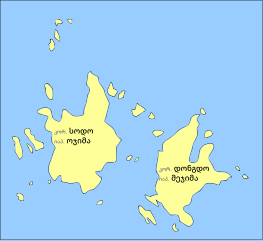
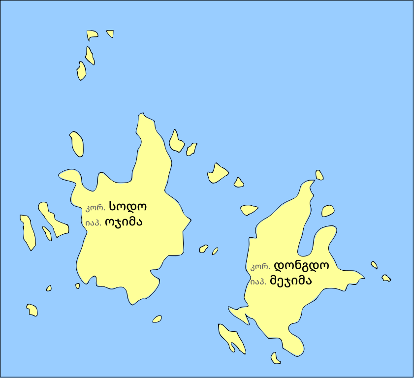
English: Map of the Liancourt Rocks
ქართული: ლიანკურის კლდეების რუკა |
| Date | (UTC) |
| Source | |
| Author |
|
| This is a retouched picture, which means that it has been digitally altered from its original version. Modifications: Transalted into Georgian. The original can be viewed here: Liancourt Rocks Map.svg:
|
I, the copyright holder of this work, hereby publish it under the following licenses:
This file is licensed under the Creative Commons Attribution-Share Alike 3.0 Unported, 2.5 Generic, 2.0 Generic and 1.0 Generic license.
- You are free:
- to share – to copy, distribute and transmit the work
- to remix – to adapt the work
- Under the following conditions:
- attribution – You must give appropriate credit, provide a link to the license, and indicate if changes were made. You may do so in any reasonable manner, but not in any way that suggests the licensor endorses you or your use.
- share alike – If you remix, transform, or build upon the material, you must distribute your contributions under the same or compatible license as the original.

|
Permission is granted to copy, distribute and/or modify this document under the terms of the GNU Free Documentation License, Version 1.2 or any later version published by the Free Software Foundation; with no Invariant Sections, no Front-Cover Texts, and no Back-Cover Texts. A copy of the license is included in the section entitled GNU Free Documentation License. |
You may select the license of your choice.
Original upload log
edit
This image is a derivative work of the following images:
- File:Liancourt_Rocks_Map.svg licensed with Cc-by-sa-3.0,2.5,2.0,1.0, GFDL
- 2009-07-16T10:39:15Z Forestfarmer 748x683 (133691 Bytes) {{Information |Description= |Source=self-made |Date= |Author= [[User:Forestfarmer|Forestfarmer]] |Permission= |other_versions= }}
- 2009-06-26T01:56:44Z Valentim 748x683 (3523 Bytes) {{Information |Description=*Description: Map of the Liancourt Rocks (disputed islands between Japan and South Korea) showing the two main islets and some of the minor ones. *Source: Drawn by User:Maksim, blanked from names an
Uploaded with derivativeFX
File history
Click on a date/time to view the file as it appeared at that time.
| Date/Time | Thumbnail | Dimensions | User | Comment | |
|---|---|---|---|---|---|
| current | 12:52, 9 February 2022 | | 748 × 683 (71 KB) | DerFuchs (talk | contribs) | Name corrections |
| 17:02, 7 March 2011 |  | 748 × 683 (104 KB) | DerFuchs (talk | contribs) | m | |
| 17:00, 7 March 2011 |  | 748 × 683 (105 KB) | DerFuchs (talk | contribs) | {{Information |Description={{en|1=Map of the Liancourt Rocks }} {{ka|1=ლიანკურის კლდეების რუკა}} |Source=*File:Liancourt_Rocks_Map.svg |Date=2011-03-07 17:00 (UTC) |Author=*File:Liancourt_Rocks_Map.svg |
You cannot overwrite this file.
File usage on Commons
The following page uses this file:
File usage on other wikis
The following other wikis use this file:
- Usage on ka.wikipedia.org