File:Lidar Fall Streaks.jpg
No higher resolution available.
Lidar_Fall_Streaks.jpg (720 × 540 pixels, file size: 333 KB, MIME type: image/jpeg)
Captions
Captions
Add a one-line explanation of what this file represents
Summary
edit
| Description |
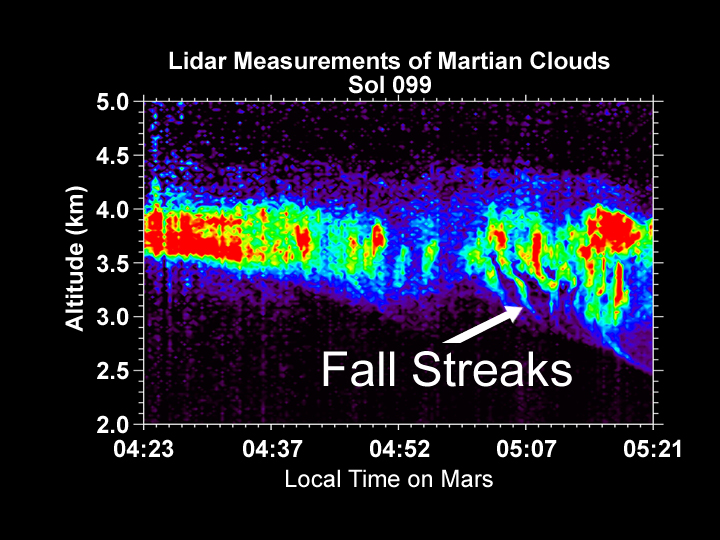
English: n the early morning hours of sol 99, Phoenix used its lidar (a skyward-pointing green laser beam) to search for clouds. The beam detected clouds at elevations between 3.5 and 4 kilometers above the surface. As the observation continued, it detected "fall streaks," where ice crystals that formed within the clouds began to descend toward the ground; as they descended, different wind speeds at different altitudes caused the sheets of falling snow crystals to shear out horizontally. When the lidar experiment quit operating at 05:21 local time, the crystals had fallen to an elevation of 2.5 kilometers, and probably fell further before they reached air that was dry enough to cause the crystals to sublimate back into a gas. Later in the season, the falling snow may survive all the way to the surface. |
| Date | |
| Source | http://www.planetary.org/blog/article/00001666/ |
| Author | NASA / JPL / UA / MET team |
Licensing
edit
| This file is in the public domain in the United States because it was solely created by NASA. NASA copyright policy states that "NASA material is not protected by copyright unless noted". (See Template:PD-USGov, NASA copyright policy page or JPL Image Use Policy.) | ||
 |
Warnings:
|
File history
Click on a date/time to view the file as it appeared at that time.
| Date/Time | Thumbnail | Dimensions | User | Comment | |
|---|---|---|---|---|---|
| current | 17:45, 17 October 2008 | | 720 × 540 (333 KB) | KGyST (talk | contribs) | {{Information |Description={{en|1=n the early morning hours of sol 99, Phoenix used its lidar (a skyward-pointing green laser beam) to search for clouds. The beam detected clouds at elevations between 3.5 and 4 kilometers above the surface. As the observa |
You cannot overwrite this file.
File usage on Commons
There are no pages that use this file.
File usage on other wikis
The following other wikis use this file:
- Usage on fr.wikipedia.org
- Usage on hu.wikipedia.org