File:Ligne N, schéma de la ligne.png

Size of this preview: 800 × 351 pixels. Other resolutions: 320 × 140 pixels | 640 × 281 pixels | 1,024 × 450 pixels | 1,280 × 562 pixels | 2,378 × 1,044 pixels.
Original file (2,378 × 1,044 pixels, file size: 294 KB, MIME type: image/png)
Captions
Captions
Add a one-line explanation of what this file represents
Summary
edit| Description |
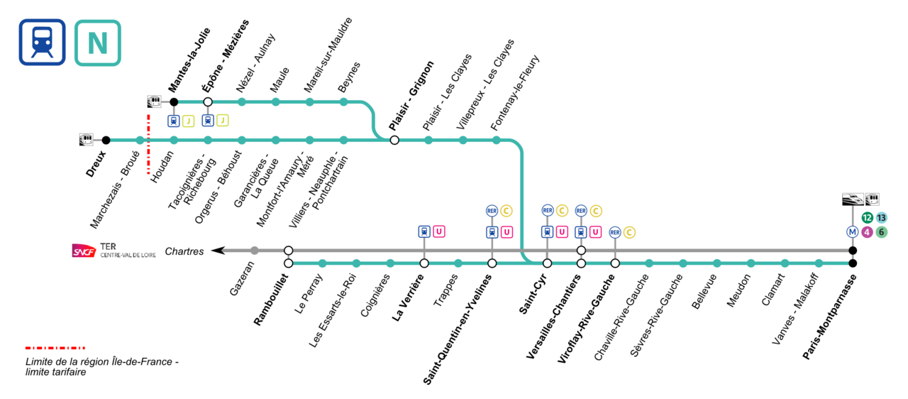
Français : Plan schématique de la ligne N du Transilien avec indication des correspondances (RER, Transilien, métro, tram, autres trains). |
|||
| Date | ||||
| Source | Own work | |||
| Author | P.poschadel | |||
| Permission (Reusing this file) |
|


Licensing
edit
I, the copyright holder of this work, hereby publish it under the following licenses:

|
Permission is granted to copy, distribute and/or modify this document under the terms of the GNU Free Documentation License, Version 1.2 or any later version published by the Free Software Foundation; with no Invariant Sections, no Front-Cover Texts, and no Back-Cover Texts. A copy of the license is included in the section entitled GNU Free Documentation License. |
This file is licensed under the Creative Commons Attribution-Share Alike 3.0 Unported, 2.5 Generic, 2.0 Generic and 1.0 Generic license.
- You are free:
- to share – to copy, distribute and transmit the work
- to remix – to adapt the work
- Under the following conditions:
- attribution – You must give appropriate credit, provide a link to the license, and indicate if changes were made. You may do so in any reasonable manner, but not in any way that suggests the licensor endorses you or your use.
- share alike – If you remix, transform, or build upon the material, you must distribute your contributions under the same or compatible license as the original.
You may select the license of your choice.
File history
Click on a date/time to view the file as it appeared at that time.
| Date/Time | Thumbnail | Dimensions | User | Comment | |
|---|---|---|---|---|---|
| current | 07:05, 24 October 2016 | | 2,378 × 1,044 (294 KB) | Floppy36 (talk | contribs) | TER Centre est devenue Ter Centre val d eloire |
| 00:13, 8 September 2016 |  | 2,378 × 1,044 (342 KB) | M0tty (talk | contribs) | Merci de ne pas réduire les dimensions du fichier, on ne sait plus rien lire... Reverted to version as of 09:43, 21 December 2012 (UTC) | |
| 15:29, 7 September 2016 |  | 600 × 263 (58 KB) | The BurnPheonix (talk | contribs) | corr | |
| 15:28, 7 September 2016 |  | 600 × 263 (58 KB) | The BurnPheonix (talk | contribs) | correspondances | |
| 09:43, 21 December 2012 |  | 2,378 × 1,044 (342 KB) | P.poschadel (talk | contribs) | Corr. Versailles-Ch. | |
| 20:10, 20 December 2012 |  | 2,378 × 1,044 (342 KB) | P.poschadel (talk | contribs) | Typo. | |
| 21:36, 19 December 2012 |  | 2,378 × 1,044 (345 KB) | P.poschadel (talk | contribs) | {{Information |Description ={{fr|1=Plan schématique de la ligne N du Transilien avec indication des correspondances (RER, Transilien, métro, tram, autres trains).}} |Source ={{own}} |Author =P.poschadel |Date ... |
You cannot overwrite this file.
File usage on Commons
The following page uses this file:
File usage on other wikis
The following other wikis use this file:
- Usage on de.wikipedia.org