File:Linemap of Nagoya Municipal Subway H29-.svg

Size of this PNG preview of this SVG file: 598 × 599 pixels. Other resolutions: 240 × 240 pixels | 479 × 480 pixels | 767 × 768 pixels | 1,022 × 1,024 pixels | 2,044 × 2,048 pixels | 1,091 × 1,093 pixels.
Original file (SVG file, nominally 1,091 × 1,093 pixels, file size: 1.18 MB)
Captions
Captions
Add a one-line explanation of what this file represents
Summary edit
| Description |
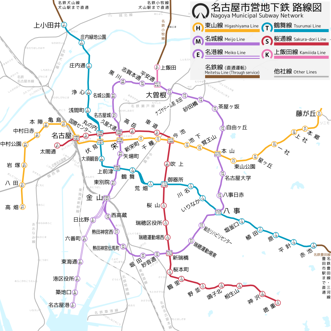
English: Linemap of Nagoya Municipal Subway (Transportation Bureau City of Nagoya)
This sign system since 2018. 日本語: 名古屋市営地下鉄(名古屋市交通局)路線図 路線記号は平成29年に採用されたもの |
| Date | |
| Source | Own work |
| Author | ButuCC |
Licensing edit
I, the copyright holder of this work, hereby publish it under the following license:
This file is licensed under the Creative Commons Attribution-Share Alike 4.0 International license.
- You are free:
- to share – to copy, distribute and transmit the work
- to remix – to adapt the work
- Under the following conditions:
- attribution – You must give appropriate credit, provide a link to the license, and indicate if changes were made. You may do so in any reasonable manner, but not in any way that suggests the licensor endorses you or your use.
- share alike – If you remix, transform, or build upon the material, you must distribute your contributions under the same or compatible license as the original.
File history
Click on a date/time to view the file as it appeared at that time.
| Date/Time | Thumbnail | Dimensions | User | Comment | |
|---|---|---|---|---|---|
| current | 12:06, 4 January 2023 | | 1,091 × 1,093 (1.18 MB) | ButuCC (talk | contribs) | kaimei |
| 16:48, 11 March 2022 |  | 1,091 × 1,093 (1.18 MB) | ButuCC (talk | contribs) | kohoku | |
| 15:59, 26 February 2018 |  | 1,091 × 1,093 (1.18 MB) | ButuCC (talk | contribs) | User created page with UploadWizard |
You cannot overwrite this file.
File usage on Commons
The following 13 pages use this file:
- 名古屋市
- User:ButuCC/Image/Map
- User:Chumwa/OgreBot/Potential transport maps/2018 February 19-28
- User:Chumwa/OgreBot/Public transport information/2018 February 19-28
- User:Chumwa/OgreBot/Public transport information/2022 March 11-20
- User:Chumwa/OgreBot/Public transport information/2023 January 1-10
- User:Chumwa/OgreBot/Transport Maps/2018 February 19-28
- User:Chumwa/OgreBot/Transport Maps/2022 March 11-20
- User:Chumwa/OgreBot/Transport Maps/2023 January 1-10
- User:Chumwa/OgreBot/Travel and communication maps/2018 February 19-28
- User:콩가루/일본철도/2022 March
- User:콩가루/일본철도/2023 January
- Category:Nagoya Municipal Subway
File usage on other wikis
The following other wikis use this file:
- Usage on ar.wikipedia.org
- Usage on de.wikivoyage.org
- Usage on es.wikipedia.org
- Usage on fi.wikipedia.org
- Usage on ja.wikipedia.org
- Usage on ja.wikivoyage.org
- Usage on www.wikidata.org
- Usage on zh.wikipedia.org