File:Linenhall Stables 2008 - Southeastern range - geograph.org.uk - 1281852.jpg
No higher resolution available.
Linenhall_Stables_2008_-_Southeastern_range_-_geograph.org.uk_-_1281852.jpg (640 × 480 pixels, file size: 132 KB, MIME type: image/jpeg)
Captions
Captions
Add a one-line explanation of what this file represents
Summary
edit
| Description |
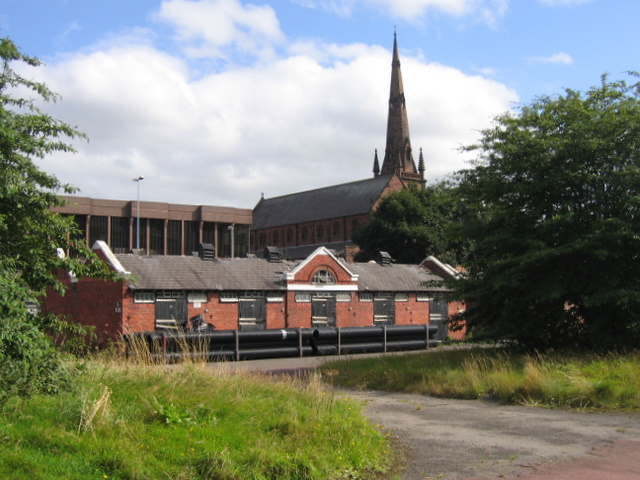
English: Linenhall Stables 2008 - Southeastern range Looking towards the southeastern section of the Linenhall Stables site. Slates removed in the gullies and behind the gable ends suggests that the lead flashing has been taken. The structure behind the stables to the left is the multi-storey car park adjoining the Crowne Plaza Hotel, and the spire belongs to the Guildhall in Watergate Street, formerly Holy Trinity church.
The Linenhall Stables were built just after the First World War on the site of the historic Linenhall. The stables served the Roodee racecourse, despite the fact that the horses then had to walk some distance over tarmac roads. In the early 2000s agreement was reached for new state of the art stables to be built on the old gasworks site with access to the racecourse through one of the arches of the famous railway viaduct. Now redundant the Linenhall Stables site is earmarked for redevelopment once again, and following acts of theft and vandalism the site was cleared in April 2009. The photo was taken during a Heritage Weekend tour. |
| Date | |
| Source | From geograph.org.uk |
| Author | John S Turner |
| Attribution (required by the license) | John S Turner / Linenhall Stables 2008 - Southeastern range / |
| Camera location | | View this and other nearby images on: OpenStreetMap |
|---|
_heading:112.00&language=en)
| Object location | | View this and other nearby images on: OpenStreetMap |
|---|
_heading:112.00&language=en)
Licensing
edit

|
This image was taken from the Geograph project collection. See this photograph's page on the Geograph website for the photographer's contact details. The copyright on this image is owned by John S Turner and is licensed for reuse under the Creative Commons Attribution-ShareAlike 2.0 license.
|
This file is licensed under the Creative Commons Attribution-Share Alike 2.0 Generic license.
Attribution: John S Turner
- You are free:
- to share – to copy, distribute and transmit the work
- to remix – to adapt the work
- Under the following conditions:
- attribution – You must give appropriate credit, provide a link to the license, and indicate if changes were made. You may do so in any reasonable manner, but not in any way that suggests the licensor endorses you or your use.
- share alike – If you remix, transform, or build upon the material, you must distribute your contributions under the same or compatible license as the original.
File history
Click on a date/time to view the file as it appeared at that time.
| Date/Time | Thumbnail | Dimensions | User | Comment | |
|---|---|---|---|---|---|
| current | 06:28, 27 February 2011 | | 640 × 480 (132 KB) | GeographBot (talk | contribs) | == {{int:filedesc}} == {{Information |description={{en|1=Linenhall Stables 2008 - Southeastern range Looking towards the southeastern section of the Linenhall Stables site. Slates removed in the gullies and behind the gable ends suggests that the lead fl |
You cannot overwrite this file.
File usage on Commons
There are no pages that use this file.