File:Link light rail geographic map.svg

Size of this PNG preview of this SVG file: 550 × 600 pixels. Other resolutions: 220 × 240 pixels | 440 × 480 pixels | 705 × 768 pixels | 939 × 1,024 pixels | 1,879 × 2,048 pixels | 1,600 × 1,744 pixels.
Original file (SVG file, nominally 1,600 × 1,744 pixels, file size: 597 KB)
Captions
Captions
Add a one-line explanation of what this file represents
Summary edit

|
This image is expected to always be the most recent one. Feel free to update it when needed.
|
| Description |
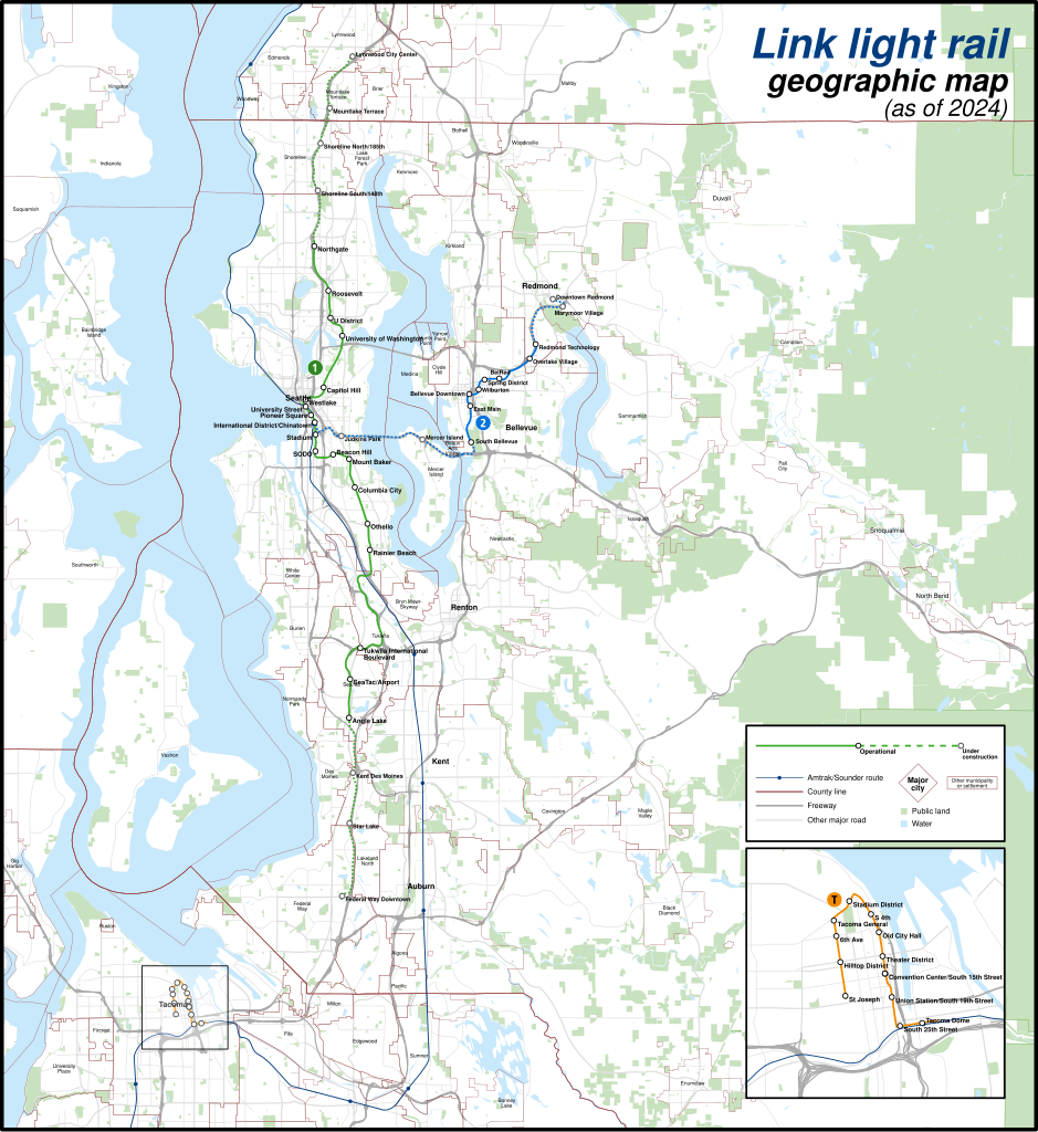
English: A geographically-accurate map of lines of the Link light rail, including parts under construction (dashed in map), overlayed on a basemap containing the Silver Line and commuter rail lines, municipalities, roads, water areas, area landmarks, and green spaces. Shapefiles from the United States Census Bureau, the U.S. Geological Survey (USGS) Gap Analysis Project (GAP), Sound Transit, and OpenStreetMap (© OpenStreetMap contributors), converted with Mapshaper and Inkscape (Mercator projection). |
| Date | |
| Source | Own work |
| Author | Twotwofourtysix |
Licensing edit
I, the copyright holder of this work, hereby publish it under the following license:
This file is licensed under the Creative Commons Attribution-Share Alike 4.0 International license.
- You are free:
- to share – to copy, distribute and transmit the work
- to remix – to adapt the work
- Under the following conditions:
- attribution – You must give appropriate credit, provide a link to the license, and indicate if changes were made. You may do so in any reasonable manner, but not in any way that suggests the licensor endorses you or your use.
- share alike – If you remix, transform, or build upon the material, you must distribute your contributions under the same or compatible license as the original.
File history
Click on a date/time to view the file as it appeared at that time.
| Date/Time | Thumbnail | Dimensions | User | Comment | |
|---|---|---|---|---|---|
| current | 02:49, 5 May 2024 | | 1,600 × 1,744 (597 KB) | Twotwofourtysix (talk | contribs) | Update with opening of line section |
| 07:58, 4 May 2024 |  | 1,600 × 1,744 (635 KB) | OrdinaryScarlett (talk | contribs) | Update date | |
| 07:01, 4 May 2024 |  | 1,600 × 1,744 (673 KB) | SounderBruce (talk | contribs) | Remove CDP "boundaries" that change with every census; cleanup label placement on 2 Line | |
| 02:41, 1 May 2024 |  | 1,600 × 1,744 (651 KB) | OrdinaryScarlett (talk | contribs) | Update 2 Line and Lynnwood and Federal Way Link Extension station names | |
| 20:05, 19 January 2024 |  | 1,600 × 1,744 (690 KB) | SounderBruce (talk | contribs) | Removing most labels for CDPs, which are arbitrarily assigned by the Census Bureau and change frequently; boundaries should also be deleted at some point | |
| 14:18, 19 January 2024 |  | 1,600 × 1,744 (650 KB) | Twotwofourtysix (talk | contribs) | Adds legend & title, adjusts colours | |
| 15:58, 18 January 2024 |  | 1,600 × 1,744 (1.76 MB) | Twotwofourtysix (talk | contribs) | Uploaded own work with UploadWizard |
You cannot overwrite this file.
File usage on Commons
The following 10 pages use this file:
- User:Chumwa/OgreBot/Public transport information/2024 January 11-20
- User:Chumwa/OgreBot/Public transport information/2024 May 1-10
- User:Chumwa/OgreBot/Transport Maps/2024 January 11-20
- User:Chumwa/OgreBot/Transport Maps/2024 May 1-10
- User:Chumwa/OgreBot/Travel and communication maps/2024 May 1-10
- User:GeorgR (de)/Rail Transport in the US/2024 January
- User:GeorgR (de)/Rail Transport in the US/2024 May
- User:Twotwofourtysix
- Commons:Graphic Lab/Map workshop/Archive/2024
- Category:Link light rail
File usage on other wikis
The following other wikis use this file:
- Usage on ca.wikipedia.org
- Usage on cs.wikipedia.org
- Usage on de.wikipedia.org
- Usage on de.wikivoyage.org
- Usage on en.wikipedia.org
- Usage on es.wikipedia.org
- Usage on fa.wikipedia.org
- Usage on fr.wikipedia.org
- Usage on it.wikipedia.org
- Usage on mr.wikipedia.org
- Usage on uk.wikipedia.org
- Usage on www.wikidata.org
- Usage on zh.wikipedia.org