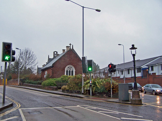
File:Livery Dole, Exeter - geograph.org.uk - 1638930.jpg
Livery_Dole,_Exeter_-_geograph.org.uk_-_1638930.jpg (640 × 480 pixels, file size: 82 KB, MIME type: image/jpeg)
Captions
Captions
Summary edit
| DescriptionLivery Dole, Exeter - geograph.org.uk - 1638930.jpg |
English: Livery Dole, Exeter. This is a triangle of land between Heavitree Road, Polsloe Road and Magdalen Road. From the Old English Leofhere who owned the land and dole, meaning a piece of land. An article in the Flying Post in 1848 stated that the first mention of Livery Dole was in a deed of 1 August 1278, and again in an Act of Parliament in 1437. Henry VI was met by clergymen from Exeter, clothed in their copes and vestments, at Livery Dole in 1452.
Livery Dole was used as a place of execution for those who committed murder, witchcraft, heresy or treason. In August 1431, Drew Steyner was burnt at the stake at Livery Dole while a hundred years later Thomas Benet, the Protestant Martyr suffered the same fate there. Samuel Holmyard was found guilty of printing forged banknotes and hung there. (Extracts from 'Exeter Memories' - http://www.exetermemories.co.uk/ ). See also 1638917 The Victorian lamp post on the right is inscribed with 'CHARLES GEORGE GORDON 26TH JANUARY 1885'. General Gordon who was killed in the siege of Khartoum in 1885, was a close friend of the Heavitree vicar, Prebendary Barnes, father of Dame Irene Vanbrugh. Barnes was deeply upset at Gordon's death and paid for the memorial. General Gordon had family connections with Exeter and his father is buried in the St Thomas churchyard. See lamp post detail - 1638952 |
| Date | |
| Source | From geograph.org.uk |
| Author | Richard Dorrell |
| Attribution (required by the license) InfoField | Richard Dorrell / Livery Dole, Exeter / |
InfoField | Richard Dorrell / Livery Dole, Exeter |
| Camera location | 50° 43′ 18″ N, 3° 30′ 32″ W | View this and other nearby images on: OpenStreetMap |
|---|
| Object location | 50° 43′ 19″ N, 3° 30′ 35″ W | View this and other nearby images on: OpenStreetMap |
|---|
Licensing edit

|
This image was taken from the Geograph project collection. See this photograph's page on the Geograph website for the photographer's contact details. The copyright on this image is owned by Richard Dorrell and is licensed for reuse under the Creative Commons Attribution-ShareAlike 2.0 license.
|
- You are free:
- to share – to copy, distribute and transmit the work
- to remix – to adapt the work
- Under the following conditions:
- attribution – You must give appropriate credit, provide a link to the license, and indicate if changes were made. You may do so in any reasonable manner, but not in any way that suggests the licensor endorses you or your use.
- share alike – If you remix, transform, or build upon the material, you must distribute your contributions under the same or compatible license as the original.
File history
Click on a date/time to view the file as it appeared at that time.
| Date/Time | Thumbnail | Dimensions | User | Comment | |
|---|---|---|---|---|---|
| current | 16:57, 4 March 2011 |  | 640 × 480 (82 KB) | GeographBot (talk | contribs) | == {{int:filedesc}} == {{Information |description={{en|1=Livery Dole, Exeter This is a triangle of land between Heavitree Road, Polsloe Road and Magdalen Road. From the Old English Leofhere who owned the land and dole, meaning a piece of land. An article |
You cannot overwrite this file.
File usage on Commons
There are no pages that use this file.
File usage on other wikis
The following other wikis use this file:
- Usage on en.wikipedia.org
Metadata
This file contains additional information such as Exif metadata which may have been added by the digital camera, scanner, or software program used to create or digitize it. If the file has been modified from its original state, some details such as the timestamp may not fully reflect those of the original file. The timestamp is only as accurate as the clock in the camera, and it may be completely wrong.
| _error | 0 |
|---|
