File:Localización de Canarias new.svg

Size of this PNG preview of this SVG file: 686 × 518 pixels. Other resolutions: 318 × 240 pixels | 636 × 480 pixels | 1,017 × 768 pixels | 1,280 × 967 pixels | 2,560 × 1,933 pixels.
Original file (SVG file, nominally 686 × 518 pixels, file size: 502 KB)
Captions
Captions
Add a one-line explanation of what this file represents
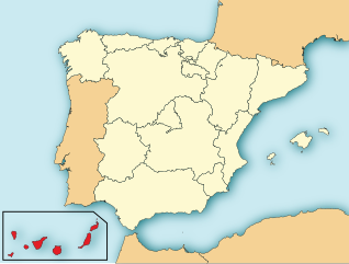
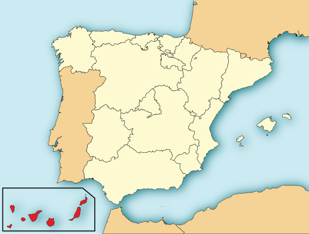
| Description | Map of Spain with Canary Islands highlighted. |
| Date | (UTC) |
| Source | |
| Author |
|
| SVG development | This locator map was created with Adobe Illustrator. |
I, the copyright holder of this work, hereby publish it under the following licenses:
This file is licensed under the Creative Commons Attribution-Share Alike 3.0 Unported license.
- You are free:
- to share – to copy, distribute and transmit the work
- to remix – to adapt the work
- Under the following conditions:
- attribution – You must give appropriate credit, provide a link to the license, and indicate if changes were made. You may do so in any reasonable manner, but not in any way that suggests the licensor endorses you or your use.
- share alike – If you remix, transform, or build upon the material, you must distribute your contributions under the same or compatible license as the original.

|
Permission is granted to copy, distribute and/or modify this document under the terms of the GNU Free Documentation License, Version 1.2 or any later version published by the Free Software Foundation; with no Invariant Sections, no Front-Cover Texts, and no Back-Cover Texts. A copy of the license is included in the section entitled GNU Free Documentation License. |
You may select the license of your choice.
Original upload log edit
This image is a derivative work of the following images:
- File:Localización_de_Islas_Baleares.svg licensed with Cc-by-sa-3.0, GFDL
- 2009-07-16T19:45:42Z Ichwan Palongengi 690x522 (574748 Bytes) {{Information |Description=Map of Spain with Balearic Islands highlighted. |Source=[[:File:EspañaLoc.svg]] |Date=July 16, 2009 |Author= [[User:Ichwan Palongengi|Ichwan Palongengi]] |Permission= |other_versions= }} [[Categor
Uploaded with derivativeFX
File history
Click on a date/time to view the file as it appeared at that time.
| Date/Time | Thumbnail | Dimensions | User | Comment | |
|---|---|---|---|---|---|
| current | 19:51, 4 August 2010 | | 686 × 518 (502 KB) | Orionist (talk | contribs) | removed border and artifacts, various other fixes |
| 15:13, 11 August 2009 |  | 690 × 522 (562 KB) | Magairlin (talk | contribs) | {{Information |Description=Map of Spain with Balearic Islands highlighted. |Source=*File:Localización_de_Islas_Baleares.svg |Date=2009-08-11 15:10 (UTC) |Author=*File:Localización_de_Islas_Baleares.svg: [[User:Ichwan Palongengi|Ichwan Palong |
You cannot overwrite this file.
File usage on Commons
More than 100 pages use this file. The following list shows the first 100 pages that use this file only. A full list is available.
- Autonomous communities of Spain
- Template:AviationYear-CanaryIslands
- Template:Buildingphotoyear-Canary Islands
- Template:CanaryIslandsByIslandYear
- Template:CanaryIslandsByMonthYear
- Template:Churchphotoyear-Canary Islands
- Category:2009 in the Canary Islands by island
- Category:2009 in the Canary Islands by month
- Category:2010 in aviation in the Canary Islands
- Category:2010 in the Canary Islands by island
- Category:2010 in the Canary Islands by month
- Category:2011 in aviation in the Canary Islands
- Category:2011 in the Canary Islands by island
- Category:2011 in the Canary Islands by month
- Category:2012 in aviation in the Canary Islands
- Category:2012 in the Canary Islands by island
- Category:2012 in the Canary Islands by month
- Category:2018 in the Canary Islands by island
- Category:2018 in the Canary Islands by month
- Category:2019 in the Canary Islands by island
- Category:2019 in the Canary Islands by month
- Category:2020 in the Canary Islands by island
- Category:2020 in the Canary Islands by month
- Category:Aerial photographs of the Canary Islands
- Category:Animals of the Canary Islands
- Category:Arachnids of the Canary Islands
- Category:Automobiles in the Canary Islands
- Category:Bandstands in the Canary Islands
- Category:Benches in the Canary Islands
- Category:Biodiversity buses in the Canary Islands
- Category:Births in the Canary Islands
- Category:Botanical gardens in the Canary Islands
- Category:Buildings in the Canary Islands photographed in 2008
- Category:Buildings in the Canary Islands photographed in 2009
- Category:Buildings in the Canary Islands photographed in 2010
- Category:Buildings in the Canary Islands photographed in 2011
- Category:Buildings in the Canary Islands photographed in 2012
- Category:Buildings in the Canary Islands photographed in 2013
- Category:Buildings in the Canary Islands photographed in 2014
- Category:Buildings in the Canary Islands photographed in 2018
- Category:Bus stations in the Canary Islands
- Category:Bus stops in the Canary Islands
- Category:Bus transport in the Canary Islands
- Category:Buses in the Canary Islands
- Category:Churches in the Canary Islands photographed in 2010
- Category:Churches in the Canary Islands photographed in 2011
- Category:Churches in the Canary Islands photographed in 2012
- Category:Coats of arms of municipalities of the Canary Islands
- Category:Coleoptera of the Canary Islands
- Category:Convents in the Canary Islands
- Category:Crustaceans of the Canary Islands
- Category:Deaths in the Canary Islands
- Category:Deckchairs in the Canary Islands
- Category:Diagrams of road number signs of the Canary Islands
- Category:Diptera of the Canary Islands
- Category:Dirt roads in the Canary Islands
- Category:Featured pictures of animals from the Canary Islands
- Category:Featured pictures of birds from the Canary Islands
- Category:Featured pictures of flowers from the Canary Islands
- Category:Featured pictures of the Canary Islands
- Category:Fissure volcanism of the Canary Islands
- Category:Flags of municipalities of the Canary Islands
- Category:Furniture in the Canary Islands
- Category:Geohazards in the Canary Islands
- Category:Hemiptera of the Canary Islands
- Category:Hymenoptera of the Canary Islands
- Category:Images of the Canary Islands
- Category:Insects of the Canary Islands
- Category:Lepidoptera of the Canary Islands
- Category:Manhole covers in the Canary Islands
- Category:Maps of the Canary Islands by island
- Category:Mass movements (geology) in the Canary Islands
- Category:Mills in the Canary Islands
- Category:Municipal police automobiles in the Canary Islands
- Category:Nature of the Canary Islands
- Category:Odonata of the Canary Islands
- Category:Orthoptera of the Canary Islands
- Category:Panoramics in the Canary Islands
- Category:Pipe organs in the Canary Islands
- Category:Populated places in the Canary Islands
- Category:Remote views of the Canary Islands
- Category:Road transport in the Canary Islands
- Category:SVG flags of municipalities of the Canary Islands
- Category:Satellite pictures of the Canary Islands
- Category:Special Areas of Conservation in Canary Islands
- Category:Street lights in the Canary Islands
- Category:Street signs in the Canary Islands
- Category:Street signs in the Canary Islands by city
- Category:Structures in the Canary Islands
- Category:Symbols of municipalities of the Canary Islands
- Category:Taxis in the Canary Islands
- Category:Tourism in the Canary Islands
- Category:Transport companies of the Canary Islands
- Category:Trucks in the Canary Islands
- Category:Vehicles in the Canary Islands
- Category:Videos from the Canary Islands
- Category:Views of the Canary Islands
- Category:Villages in the Canary Islands
- Category:Volcanism of the Canary Islands
- Category:Volcanoes in the Canary Islands
View more links to this file.
File usage on other wikis
The following other wikis use this file:
- Usage on af.wikipedia.org
- Usage on ar.wikipedia.org
- Usage on ast.wikipedia.org
- Usage on ca.wikipedia.org
- Usage on cs.wikipedia.org
- Usage on de.wikivoyage.org
- Usage on diq.wikipedia.org
- Usage on en.wikipedia.org
- Usage on es.wikipedia.org
- Usage on eu.wikipedia.org
- Usage on ext.wikipedia.org
- Usage on fr.wikipedia.org
- Usage on hu.wikipedia.org
- Usage on ja.wikipedia.org
- Usage on ko.wikipedia.org
- Usage on la.wikipedia.org
- Usage on oc.wikipedia.org
- Usage on ru.wikivoyage.org
- Usage on sc.wikipedia.org
- Usage on th.wikipedia.org
- Usage on war.wikipedia.org