File:LocatieLeiden.png
No higher resolution available.
LocatieLeiden.png (280 × 130 pixels, file size: 8 KB, MIME type: image/png)
Captions
Captions
Add a one-line explanation of what this file represents

|
This locator map image could be re-created using vector graphics as an SVG file. This has several advantages; see Commons:Media for cleanup for more information. If an SVG form of this image is available, please upload it and afterwards replace this template with
{{vector version available|new image name}}.
It is recommended to name the SVG file “LocatieLeiden.svg”—then the template Vector version available (or Vva) does not need the new image name parameter. |
| This work has been released into the public domain by its author, Mtcv. This applies worldwide. In some countries this may not be legally possible; if so: |
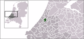
Locatie gemeente Leiden. Afbeelding gemaakt door nl:gebruiker:Mtcv en vrij te gebruiken.
Summary edit
| Description |
Location of Leiden Español: Localización de Leiden
Svenska: position i Zuid-Holland |
| Date | 8 December 2003 |
| Source | Own work |
| Author | nl:Gebruiker:Mtcv |
| Permission (Reusing this file) |
first upload to nl: 8 dec 2003 14:03 by nl:Gebruiker:Mtcv |
File history
Click on a date/time to view the file as it appeared at that time.
| Date/Time | Thumbnail | Dimensions | User | Comment | |
|---|---|---|---|---|---|
| current | 17:14, 27 July 2006 | | 280 × 130 (8 KB) | PPP (talk | contribs) | Updated version with new city borders of Katwijk and community borders of Teylingen. |
| 17:40, 19 November 2004 |  | 280 × 130 (8 KB) | Eugene van der Pijll (talk | contribs) | {{GFDL}} |
You cannot overwrite this file.
File usage on Commons
The following page uses this file:
File usage on other wikis
The following other wikis use this file:
- Usage on af.wikipedia.org
- Usage on cs.wikipedia.org
- Usage on de.wikipedia.org
- Usage on fr.wikipedia.org
- Usage on fy.wikipedia.org
- Usage on hr.wikipedia.org
- Usage on id.wikipedia.org
- Usage on io.wikipedia.org
- Usage on is.wikipedia.org
- Usage on jv.wikipedia.org
- Usage on ko.wikipedia.org
- Usage on li.wikipedia.org
- Usage on nl.wikipedia.org
- Usage on nn.wikipedia.org
- Usage on no.wikipedia.org
- Usage on pl.wikipedia.org
- Usage on pl.wikivoyage.org
- Usage on pnb.wikipedia.org
- Usage on ro.wikipedia.org
- Usage on sl.wikipedia.org
- Usage on sv.wikipedia.org
- Usage on th.wikipedia.org
- Usage on vi.wikipedia.org