File:LocationNSAmUNGeoscheme.png

Size of this preview: 600 × 600 pixels. Other resolutions: 240 × 240 pixels | 480 × 480 pixels.
Original file (800 × 800 pixels, file size: 22 KB, MIME type: image/png)
Captions
Captions
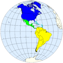
Blue - North America Green - Central America Yellow - South America Cyan - Caribbean
Summary
edit
| Description | United Nations geoscheme for the Americas. |
| Date | |
| Source | prepared from public domain maps created by w:en:User:E Pluribus Anthony. |
| Author | Spacepotato |
Legend
edit
- 0000FF: Northern America.
- 00FF00: Central America.
- 00FFFF: Caribbean.
- FFFC00: South America.
References
edit
- Composition of macro geographical (continental) regions, geographical sub-regions, and selected economic and other groupings. United Nations Statistics Division, Country and Region Codes. Revised August 28, 2007. Accessed on line October 12, 2007.
Licensing
edit
| I, the copyright holder of this work, release this work into the public domain. This applies worldwide. In some countries this may not be legally possible; if so: I grant anyone the right to use this work for any purpose, without any conditions, unless such conditions are required by law. |
See also
edit
- Image:LocationNSAm.png
- Image:LocationNSAm2.png
- Image:LocationNSAm3.png
- Image:LocationNSAngloLatin.png
File history
Click on a date/time to view the file as it appeared at that time.
| Date/Time | Thumbnail | Dimensions | User | Comment | |
|---|---|---|---|---|---|
| current | 19:02, 12 October 2007 | | 800 × 800 (22 KB) | Spacepotato (talk | contribs) | == Summary == {{Information |Description=United Nations geoscheme for the Americas. |Source=prepared from public domain maps created by w:en:User:E Pluribus Anthony. |Date=October 12, 2007. |Author= Spacepotato }} ==Legend== {{leg |
You cannot overwrite this file.
File usage on Commons
There are no pages that use this file.
File usage on other wikis
The following other wikis use this file:
- Usage on bn.wikipedia.org
- Usage on en.wikipedia.org
- Usage on es.wikipedia.org
- Usage on fr.wikipedia.org
- Usage on id.wikipedia.org
- Usage on it.wikipedia.org
- Usage on ja.wikipedia.org
- Usage on kaa.wikipedia.org
- Usage on kg.wikipedia.org
- Usage on ky.wikipedia.org
- Usage on mn.wikipedia.org
- Usage on pl.wikipedia.org
- Usage on pnb.wikipedia.org
- Usage on ru.wikipedia.org
- Usage on sr.wikipedia.org
- Usage on th.wikipedia.org
- Usage on ur.wikipedia.org
- Usage on vep.wikipedia.org
- Usage on zh.wikipedia.org