File:Location Battle-of-Alalia.PNG
No higher resolution available.
Location_Battle-of-Alalia.PNG (646 × 455 pixels, file size: 48 KB, MIME type: image/png)
Captions
Captions
Add a one-line explanation of what this file represents
Summary edit
| Description |
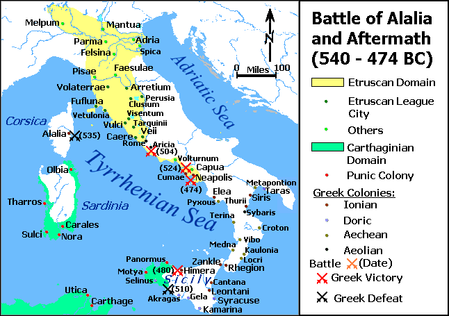
English: A map showing the approximate extent of Carthaginian and Etruscan domains and locations of major Greek, Etruscan and Punic colonies during the Battle of Alalia. The dates on the map are an approximation based on the sources I had. |
| Date |
27 October 2007 (original upload date) |
| Source |
|
| Author | Maglorbd |
| Permission (Reusing this file) |
GNU-FDL |
Licensing edit

|
Permission is granted to copy, distribute and/or modify this document under the terms of the GNU Free Documentation License, Version 1.2 or any later version published by the Free Software Foundation; with no Invariant Sections, no Front-Cover Texts, and no Back-Cover Texts. A copy of the license is included in the section entitled GNU Free Documentation License. |
Maglorbd at English Wikipedia, the copyright holder of this work, hereby publishes it under the following licenses:
|
|
Permission is granted to copy, distribute and/or modify this document under the terms of the GNU Free Documentation License, Version 1.2 or any later version published by the Free Software Foundation; with no Invariant Sections, no Front-Cover Texts, and no Back-Cover Texts. A copy of the license is included in the section entitled GNU Free Documentation License. |
This file is licensed under the Creative Commons Attribution 3.0 Unported license.
Attribution: Maglorbd at English Wikipedia
- You are free:
- to share – to copy, distribute and transmit the work
- to remix – to adapt the work
- Under the following conditions:
- attribution – You must give appropriate credit, provide a link to the license, and indicate if changes were made. You may do so in any reasonable manner, but not in any way that suggests the licensor endorses you or your use.
You may select the license of your choice.
Original upload log edit
The original description page was here. All following user names refer to en.wikipedia.
- 2007-10-27 06:58 Maglorbd 646×455×8 (49260 bytes) == Description == {{Information| |Description={{en|A map showing the approximate extent of Carthaginian and Etruscan domains and locations of major Greek, Etruscan and Punic colonies during the Battle of Alalia. The dates on the map are an approximation b
File history
Click on a date/time to view the file as it appeared at that time.
| Date/Time | Thumbnail | Dimensions | User | Comment | |
|---|---|---|---|---|---|
| current | 07:27, 5 June 2008 | | 646 × 455 (48 KB) | Filos96 (talk | contribs) | == Description == {{Information| |Description={{en|A map showing the approximate extent of Carthaginian and Etruscan domains and locations of major Greek, Etruscan and Punic colonies during the Battle of Alalia. The dates on the map are an approximation b |
You cannot overwrite this file.
File usage on Commons
There are no pages that use this file.
File usage on other wikis
The following other wikis use this file:
- Usage on br.wikipedia.org
- Usage on de.wikipedia.org
- Usage on el.wikipedia.org
- Usage on en.wikipedia.org
- Usage on eu.wikipedia.org
- Usage on fi.wikipedia.org
- Usage on it.wikipedia.org
- Usage on pl.wikipedia.org
- Usage on pt.wikipedia.org
- Usage on tr.wikipedia.org
- Usage on uk.wikipedia.org