File:Location of April 14, 2008 earthquake near French Guiana.png
No higher resolution available.
Location_of_April_14,_2008_earthquake_near_French_Guiana.png (142 × 141 pixels, file size: 18 KB, MIME type: image/png)
Captions
Captions
Add a one-line explanation of what this file represents
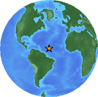
| Description | This is the location of an earthquake which hit Britain recently. It is an image from the USGS for use in a Wikinews article. Please find the appropriate Wikinews article for a description of the earthquake. | |||
| Date | ||||
| Source | feed://earthquake.usgs.gov/eqcenter/catalogs/1day-M2.5.xml | |||
| Author | Anonymous101 | |||
| Permission (Reusing this file) |
|
File history
Click on a date/time to view the file as it appeared at that time.
| Date/Time | Thumbnail | Dimensions | User | Comment | |
|---|---|---|---|---|---|
| current | 08:56, 14 April 2008 | | 142 × 141 (18 KB) | Anonymous101 (talk | contribs) | {{User:Anonymous101/Earthquake}} |
You cannot overwrite this file.
File usage on Commons
There are no pages that use this file.
File usage on other wikis
The following other wikis use this file:
- Usage on en.wikinews.org
- Usage on fr.wikinews.org