File:Location of the border between Tigray and Amhara.png
Size of this preview: 800 × 190 pixels. Other resolutions: 320 × 76 pixels | 1,027 × 244 pixels.
Original file (1,027 × 244 pixels, file size: 47 KB, MIME type: image/png)
Captions
Captions
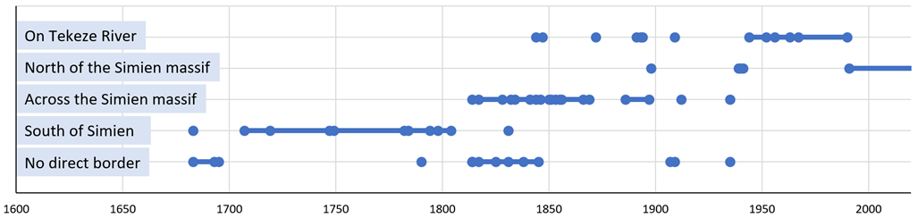
Location of the border between Tigray and Amhara through time
Summary edit
| Description |
English: Location of the border between Tigray/Tigrai/Tigre and Amhara/Gondar/Begemder, according to historical maps (n=62). Every dot represents a map in the dataset. Gaps between subsequent maps must be understood as “no information” or “period of shifting territorial control”. Conflicting information on territorial control in certain periods points to different information by cartographers. The power of such a large dataset is that the overall picture of the situation can be better grasped. |
| Date | |
| Source |
Dataset: Western Tigray in 101 historical and 18 ethno-linguistic maps (1607-2009). https://zenodo.org/record/6576524 |
| Author | Jan Nyssen |
| Camera location | | View this and other nearby images on: OpenStreetMap |
|---|
Licensing edit
This file is licensed under the Creative Commons Attribution-Share Alike 4.0 International license.
- You are free:
- to share – to copy, distribute and transmit the work
- to remix – to adapt the work
- Under the following conditions:
- attribution – You must give appropriate credit, provide a link to the license, and indicate if changes were made. You may do so in any reasonable manner, but not in any way that suggests the licensor endorses you or your use.
- share alike – If you remix, transform, or build upon the material, you must distribute your contributions under the same or compatible license as the original.
File history
Click on a date/time to view the file as it appeared at that time.
| Date/Time | Thumbnail | Dimensions | User | Comment | |
|---|---|---|---|---|---|
| current | 05:27, 6 June 2022 | 1,027 × 244 (47 KB) | Jnyssen (talk | contribs) | Uploaded a work by Jan Nyssen from Dataset: Western Tigray in 101 historical and 18 ethno-linguistic maps (1607-2009). https://zenodo.org/record/6576524 with UploadWizard |
You cannot overwrite this file.
File usage on Commons
There are no pages that use this file.