File:Location relief map Borough of Copeland.svg

Size of this PNG preview of this SVG file: 465 × 600 pixels. Other resolutions: 186 × 240 pixels | 372 × 480 pixels | 596 × 768 pixels | 794 × 1,024 pixels | 1,588 × 2,048 pixels | 1,044 × 1,346 pixels.
Original file (SVG file, nominally 1,044 × 1,346 pixels, file size: 651 KB)
Captions
Captions
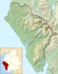
Relief map of the Borough of Copeland, Cumbria, England
Summary edit
| Description |
English: Relief map of the former Borough of Copeland, Cumbria, England in 2010. Inset highlights the Borough of Copeland among all the districts of Cumbria. The borough was abolished on 1 April 2023.
Equirectangular map projection on WGS 84 datum, with N/S stretched 170% Geographic limits:
|
| Date | |
| Source |
This file was derived from: |
| Author |

.svg)
Licensing edit
This file is licensed under the Creative Commons Attribution-Share Alike 4.0 International license.
Attribution: © Nilfanion and Dr Greg. Contains Ordnance Survey data © Crown copyright and database right 2010.
- You are free:
- to share – to copy, distribute and transmit the work
- to remix – to adapt the work
- Under the following conditions:
- attribution – You must give appropriate credit, provide a link to the license, and indicate if changes were made. You may do so in any reasonable manner, but not in any way that suggests the licensor endorses you or your use.
- share alike – If you remix, transform, or build upon the material, you must distribute your contributions under the same or compatible license as the original.
File history
Click on a date/time to view the file as it appeared at that time.
| Date/Time | Thumbnail | Dimensions | User | Comment | |
|---|---|---|---|---|---|
| current | 13:00, 29 January 2021 | | 1,044 × 1,346 (651 KB) | Dr Greg (talk | contribs) | Uploaded a work by * Cumbria UK relief location map.jpg: Nilfanion, created using Ordnance Survey data * Copeland UK ward map 2010 (blank).svg: Nilfanion, created using Ordnance Survey data * derivative work: Dr Greg from {{Derived from|Cumbria UK relief location map.jpg|Copeland UK ward map 2010 (blank).svg|display=50}} with UploadWizard |
You cannot overwrite this file.
File usage on Commons
There are no pages that use this file.
File usage on other wikis
The following other wikis use this file:
- Usage on en.wikipedia.org
- Ravenglass and Eskdale Railway
- Scafell Pike
- Scafell
- Wast Water
- Pillar (Lake District)
- Great Gable
- Bowfell
- Great End
- Crinkle Crags
- Ennerdale Water
- Hard Knott
- Harter Fell (Eskdale)
- Cold Pike
- Esk Pike
- Haystacks (Lake District)
- Buckbarrow
- High Stile
- Kirk Fell
- Pike o' Blisco
- Seatallan
- Blake Fell
- Black Combe
- St Bees Head
- Devoke Water
- Red Pike (Buttermere)
- Red Pike (Wasdale)
- High Crag
- Illgill Head
- Scoat Fell
- Lingmell
- Green Gable
- Yewbarrow
- Steeple (Lake District)
- Haycock (Lake District)
- Great Borne
- Whin Rigg
- Slight Side
- Burnbank Fell
- Green Crag
- Grike (Lake District)
- Starling Dodd
- Brandreth
- Caw Fell
- Crag Fell
- Gavel Fell
- Lank Rigg
- Middle Fell
- Innominate Tarn
- Cogra Moss
- Blea Tarn (Eskdale)
View more global usage of this file.