File:Locations and stratigraphy of the Spence Shale Lagerstätte.jpg

Size of this preview: 635 × 599 pixels. Other resolutions: 254 × 240 pixels | 509 × 480 pixels | 814 × 768 pixels | 1,085 × 1,024 pixels | 1,280 × 1,208 pixels.
Original file (1,280 × 1,208 pixels, file size: 272 KB, MIME type: image/jpeg)
Captions
Captions
Add a one-line explanation of what this file represents
Summary
edit
| Description |
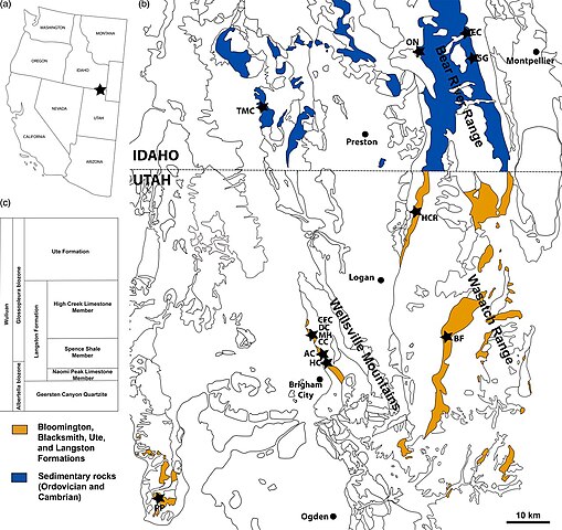
English: Fig. 1. Locations and stratigraphy of the Spence Shale Lagerstätte. (a) Map of the western USA showing the location of the Spence Shale. (b) Geological map (based on the USGS state maps for Google Earth Pro) of northern Utah and southern Idaho showing the principal localities within the Spence Shale. AC, Antimony Canyon; BF, Blacksmith Fork; CC, Cataract Canyon; CFC, Calls Fort Canyon; DC, Donation Canyon; EC, Emigration Canyon; HC, Hansen Canyon; HCR, High Creek; MH, Miners Hollow; ON, Oneida Narrows; PP, Promontory Point; SG, Spence Gulch; TMC, Two Mile Canyon. (c) Simplified stratigraphy of the Langston Formation. |
| Date | |
| Source | https://jgs.lyellcollection.org/content/176/4/609 |
| Author | Julien Kimmig, Luke C. Strotz, Sara R. Kimmig, Sven O. Egenhoff and Bruce S. Lieberman |
Licensing
edit
This file is licensed under the Creative Commons Attribution 4.0 International license.
- You are free:
- to share – to copy, distribute and transmit the work
- to remix – to adapt the work
- Under the following conditions:
- attribution – You must give appropriate credit, provide a link to the license, and indicate if changes were made. You may do so in any reasonable manner, but not in any way that suggests the licensor endorses you or your use.
File history
Click on a date/time to view the file as it appeared at that time.
| Date/Time | Thumbnail | Dimensions | User | Comment | |
|---|---|---|---|---|---|
| current | 00:18, 11 May 2022 | | 1,280 × 1,208 (272 KB) | Qohelet12 (talk | contribs) | Uploaded a work by Julien Kimmig, Luke C. Strotz, Sara R. Kimmig, Sven O. Egenhoff and Bruce S. Lieberman from https://jgs.lyellcollection.org/content/176/4/609 with UploadWizard |
You cannot overwrite this file.
File usage on Commons
There are no pages that use this file.