File:Loch Kinord - geograph.org.uk - 903441.jpg
No higher resolution available.
Loch_Kinord_-_geograph.org.uk_-_903441.jpg (640 × 427 pixels, file size: 89 KB, MIME type: image/jpeg)
Captions
Captions
Add a one-line explanation of what this file represents
Summary
edit
| Description |
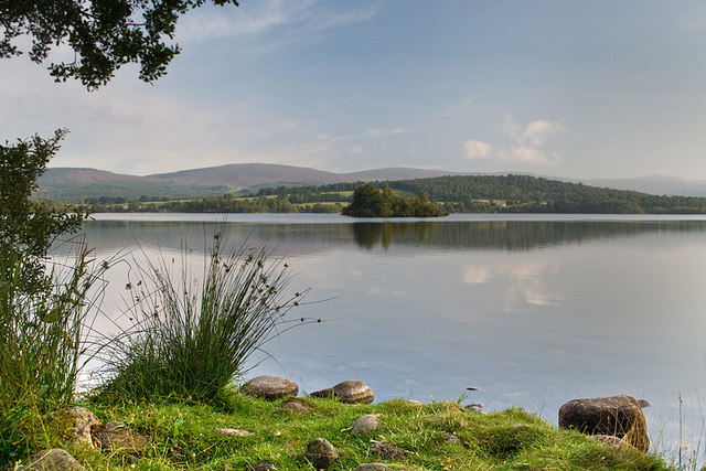
English: Loch Kinord Loch Kinord and the nearby Loch Davan were both formed when the last glaciers melted here more than 10.000 years ago. They are textbook examples of kettle holes. These were formed when large blocks of ice became separated from the melting glacier and were buried by sand and gravel. When that ice finally melted, the sand and gravel that once lay on top of the ice collapsed, leaving a hollow (kettle hole) on the ground surface which later filled with water. The lochs are relatively shallow. Loch Kinord has an average depth of about 2 metres. The shallow depth means that light can penetrate to the loch floor. Consequently, the loch has a rich flora with many species of aquatic plants recorded. |
| Date | |
| Source | From geograph.org.uk |
| Author | Nigel Corby |
| Attribution (required by the license) | Nigel Corby / Loch Kinord / |
| Camera location | | View this and other nearby images on: OpenStreetMap |
|---|
_heading:180.00&language=en)
| Object location | | View this and other nearby images on: OpenStreetMap |
|---|
_heading:180.00&language=en)
Licensing
edit

|
This image was taken from the Geograph project collection. See this photograph's page on the Geograph website for the photographer's contact details. The copyright on this image is owned by Nigel Corby and is licensed for reuse under the Creative Commons Attribution-ShareAlike 2.0 license.
|
This file is licensed under the Creative Commons Attribution-Share Alike 2.0 Generic license.
Attribution: Nigel Corby
- You are free:
- to share – to copy, distribute and transmit the work
- to remix – to adapt the work
- Under the following conditions:
- attribution – You must give appropriate credit, provide a link to the license, and indicate if changes were made. You may do so in any reasonable manner, but not in any way that suggests the licensor endorses you or your use.
- share alike – If you remix, transform, or build upon the material, you must distribute your contributions under the same or compatible license as the original.
File history
Click on a date/time to view the file as it appeared at that time.
| Date/Time | Thumbnail | Dimensions | User | Comment | |
|---|---|---|---|---|---|
| current | 19:57, 21 February 2011 | | 640 × 427 (89 KB) | GeographBot (talk | contribs) | == {{int:filedesc}} == {{Information |description={{en|1=Loch Kinord Loch Kinord and the nearby Loch Davan were both formed when the last glaciers melted here more than 10.000 years ago. They are textbook examples of kettle holes. These were formed when |
You cannot overwrite this file.
File usage on Commons
There are no pages that use this file.