File:Lokasi Sumatra Utara Kabupaten Dairi.svg

Size of this PNG preview of this SVG file: 800 × 535 pixels. Other resolutions: 320 × 214 pixels | 640 × 428 pixels | 1,024 × 684 pixels | 1,280 × 855 pixels | 2,560 × 1,710 pixels | 1,133 × 757 pixels.
Original file (SVG file, nominally 1,133 × 757 pixels, file size: 470 KB)
Captions
Captions
Add a one-line explanation of what this file represents
Summary
edit
| Description |
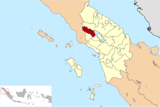
Bahasa Indonesia: Lokasi Kabupaten Dairi di Provinsi Sumatra Utara
English: Location of Dairi Regency in North Sumatra Province, Indonesia |
| Date | 7 April 2010 (original upload date) |
| Source | Transferred from id.wikipedia to Commons by Jack Merridew using CommonsHelper. |
| Author | Ewesewes at Indonesian Wikipedia |
Licensing
edit
Ewesewes at Indonesian Wikipedia, the copyright holder of this work, hereby publishes it under the following license:
This file is licensed under the Creative Commons Attribution-Share Alike 3.0 Unported license.
Attribution: Ewesewes at Indonesian Wikipedia
- You are free:
- to share – to copy, distribute and transmit the work
- to remix – to adapt the work
- Under the following conditions:
- attribution – You must give appropriate credit, provide a link to the license, and indicate if changes were made. You may do so in any reasonable manner, but not in any way that suggests the licensor endorses you or your use.
- share alike – If you remix, transform, or build upon the material, you must distribute your contributions under the same or compatible license as the original.
Original upload log
edit
The original description page was here. All following user names refer to id.wikipedia.
- 2010-04-07 04:59 Ewesewes 1133×757× (480806 bytes) Lokasi Kabupaten Dairi di Provinsi Sumatra Utara [[Kategori:Peta penunjuk posisi di Indonesia]] == Jenis lisensi == {{Self|Cc-by-sa-3.0}}
File history
Click on a date/time to view the file as it appeared at that time.
| Date/Time | Thumbnail | Dimensions | User | Comment | |
|---|---|---|---|---|---|
| current | 07:38, 24 December 2010 | | 1,133 × 757 (470 KB) | File Upload Bot (Magnus Manske) (talk | contribs) | {{BotMoveToCommons|id.wikipedia|year={{subst:CURRENTYEAR}}|month={{subst:CURRENTMONTHNAME}}|day={{subst:CURRENTDAY}}}} {{Information |Description={{id|Lokasi Kabupaten Dairi di Provinsi Sumatera Utara id:Kategori:Peta penunjuk posisi di Indonesia} |
You cannot overwrite this file.
File usage on Commons
The following 2 pages use this file:
- File:Lokasi Sumatera Utara Kabupaten Dairi.svg (file redirect)
- Category:Dairi Regency
File usage on other wikis
The following other wikis use this file:
- Usage on ace.wikipedia.org
- Usage on ban.wikipedia.org
- Usage on de.wikipedia.org
- Usage on en.wikipedia.org
- Usage on es.wikipedia.org
- Usage on gor.wikipedia.org
- Usage on id.wikipedia.org
- Daftar kabupaten dan kota di Indonesia
- Daftar kabupaten dan kota di Sumatera Utara
- Pengguna:Ewesewes/Bengkel Peta/Sumatera Utara
- Daftar kabupaten dan kota di Indonesia menurut waktu pembentukan
- Daftar kecamatan dan kelurahan di Kabupaten Dairi
- Pemilihan umum Bupati Dairi 2018
- Daftar kabupaten dan kota di Sumatera Utara berdasarkan waktu pembentukan
- Usage on it.wikipedia.org
- Usage on jv.wikipedia.org
- Usage on map-bms.wikipedia.org
- Usage on min.wikipedia.org
- Usage on ms.wikipedia.org
- Usage on nl.wikipedia.org
- Usage on ru.wikipedia.org
- Usage on tr.wikipedia.org
- Usage on vi.wikipedia.org
- Usage on www.wikidata.org
- Usage on zh-min-nan.wikipedia.org
- Usage on zh.wikipedia.org