File:Look what big teeth I've got^ - geograph.org.uk - 1672106.jpg

Original file (595 × 700 pixels, file size: 249 KB, MIME type: image/jpeg)
Captions
Captions
Summary edit
| Description |
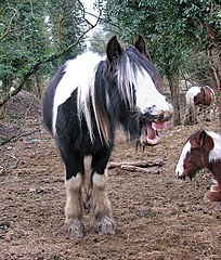
English: Look what big teeth I've got! One of the 'squatting' ponies within the security fence.
Yarefield Park is a new business development > https://www.geograph.org.uk/photo/1672069 located in Oldhall Road, just east of the A14 (Ipswich Road), south-east of the city of Norwich. Phase 1 of the development was completed in summer 2007. The location is not as yet marked on maps and satellite images still show an undeveloped site without buildings but the new industrial units can be seen on Google Streetview. A track used to lead from Oldhall Road to the long-closed rubbish dump, a short distance further to the east. This since disused track, turning off Oldhall Road, is now part of the business development site which has been surrounded by a high security fence, making the ground adjoining to the east inaccessible: the overgrown rubbish dump, now pastureland, is hemmed in by the Norwich to London mainline in the east, by the Norwich to Ely/Cambridge railway in the north and by the River Yare in the south, and access is effectively blocked by the security perimeter fence in the west > https://www.geograph.org.uk/photo/1672064. However, a whole herd of ponies has mysteriously found a way inside the fenced-off area and is grazing the green (council-owned) pastures beyond > https://www.geograph.org.uk/photo/1672106. In bad weather the animals find shelter in the woodland adjoining Oldhall Road. Food appears to be thrown to them over the very high and sturdy perimeter fence along Oldhall Road, as is evidenced by all the hay caught in the top spikes, too high up to be reachable > https://www.geograph.org.uk/photo/1672096. According to locals the ponies are owned by travellers who cut the chain link fence, led the ponies inside, and then rewired the gaps shut again > https://www.geograph.org.uk/photo/1672087. |
| Date | |
| Source | From geograph.org.uk |
| Author | Evelyn Simak |
| Attribution (required by the license) | Evelyn Simak / Look what big teeth I've got! / |
| Camera location | | View this and other nearby images on: OpenStreetMap |
|---|
_heading:202.00&language=en)
| Object location | | View this and other nearby images on: OpenStreetMap |
|---|
_heading:202.00&language=en)
Licensing edit

|
This image was taken from the Geograph project collection. See this photograph's page on the Geograph website for the photographer's contact details. The copyright on this image is owned by Evelyn Simak and is licensed for reuse under the Creative Commons Attribution-ShareAlike 2.0 license.
|
- You are free:
- to share – to copy, distribute and transmit the work
- to remix – to adapt the work
- Under the following conditions:
- attribution – You must give appropriate credit, provide a link to the license, and indicate if changes were made. You may do so in any reasonable manner, but not in any way that suggests the licensor endorses you or your use.
- share alike – If you remix, transform, or build upon the material, you must distribute your contributions under the same or compatible license as the original.
File history
Click on a date/time to view the file as it appeared at that time.
| Date/Time | Thumbnail | Dimensions | User | Comment | |
|---|---|---|---|---|---|
| current | 00:53, 5 March 2011 | | 595 × 700 (249 KB) | GeographBot (talk | contribs) | == {{int:filedesc}} == {{Information |description={{en|1=Look what big teeth I've got! One of the 'squatting' ponies within the security fence. Yarefield Park is a new business development > http://www.geograph.org.uk/photo/1672069 located in Oldhall R |
You cannot overwrite this file.
File usage on Commons
There are no pages that use this file.