File:Lorain Ohio aerial view.jpg

Size of this preview: 800 × 534 pixels. Other resolutions: 320 × 214 pixels | 640 × 427 pixels | 1,024 × 683 pixels | 1,500 × 1,001 pixels.
Original file (1,500 × 1,001 pixels, file size: 567 KB, MIME type: image/jpeg)
Captions
Captions
Add a one-line explanation of what this file represents
| Description |
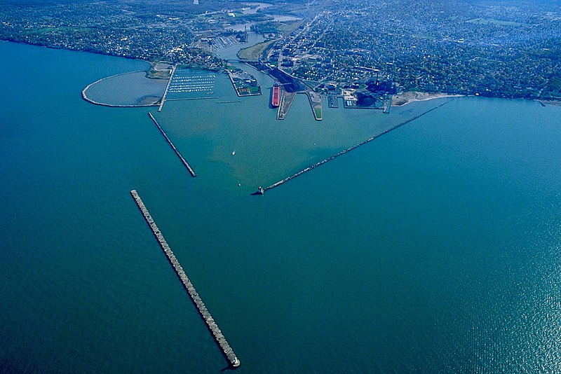
English: Aerial view of the harbor at Lorain, Ohio, USA. The Black River flows into Lake Erie in Lorain. The view is to the southeast. The U.S. Army Corps of Engineers built the breakwaters for this commercial harbor and built a confined disposal facility (CDF) for storing polluted material from dredging operations. Also constructed a small boat harbor breakwall. |
|||
| Date | ||||
| Source |
U.S. Army Corps of Engineers Digital Visual Library Image page Image description page Digital Visual Library home page |
|||
| Author | Ken Winters, U.S. Army Corps of Engineers | |||
| Permission (Reusing this file) |
|
|||
| Location | Lorain, Ohio, USA |
| Camera location | | View this and other nearby images on: OpenStreetMap |
|---|
File history
Click on a date/time to view the file as it appeared at that time.
| Date/Time | Thumbnail | Dimensions | User | Comment | |
|---|---|---|---|---|---|
| current | 22:14, 24 March 2007 | | 1,500 × 1,001 (567 KB) | DanMS (talk | contribs) | {{Information | Description = {{en|Aerial view of the harbor at Lorain, Ohio, USA. The Black River flows into Lake Erie in Lorain. The view is to the southeast. The U.S. Army Corps of Engineers built the breakwaters for this commercial harbor and buil |
You cannot overwrite this file.
File usage on Commons
There are no pages that use this file.
File usage on other wikis
The following other wikis use this file:
- Usage on de.wikipedia.org
- Usage on en.wikipedia.org
- Usage on fa.wikipedia.org
- Usage on fr.wikipedia.org
- Usage on it.wikipedia.org
- Usage on ja.wikipedia.org
- Usage on sh.wikipedia.org
- Usage on www.wikidata.org