File:Lorenzo 2019-09-28 1605Z (Worldview).jpg

Original file (5,766 × 3,937 pixels, file size: 4.65 MB, MIME type: image/jpeg)
Captions
Captions
Summary
edit.jpg&action=edit§ion=1)
| Description |
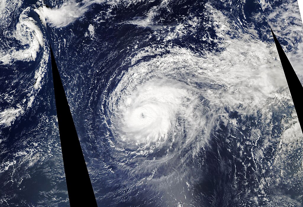
English: On September 28, 2019, Hurricane Lorenzo made history. According to the National Hurricane Center, the category 5 hurricane traveled farther east and north in the Atlantic Ocean than any previous storm of the same strength. By October 2, the hurricane had weakened to a category 1, but it still brought winds of 145 kilometers (90 miles) per hour to the Azores archipelago. The storm is expected to bring heavy rain to Ireland later this week.
The image shows the hurricane on September 28, when it was a category 5 storm. The image were acquired by the Moderate Resolution Imaging Spectroradiometer (MODIS) instruments on NASA’s Aqua satellite. Lorenzo was the second category 5 hurricane in the Atlantic Ocean this year; the first was Hurricane Dorian. Hurricanes typically do not reach this strength in the northeastern Atlantic Ocean because water temperatures are usually too cold and wind shear conditions can hinder hurricane development. However, satellite measurements of sea surface temperature anomalies showed that the water under the storm was warm enough to give it an energy boost. Hurricanes rarely travel this far east or north in the Atlantic; the last storm to brush the Azores archipelago was tropical storm Alex in 2016. In this case, news outlets noted that a large high pressure area in the western Atlantic blocked the storm from traveling toward North America. Research has shown that the average latitude at which tropical cyclones reach their peak intensity has been shifting closer to the poles over the past 30 years. In other words, hurricanes in the northern hemisphere are reaching their maximum intensity at latitudes farther north than decades ago. “It’s basically consistent with the oceans warming,” said Tim Hall, a hurricane climatologist at NASA’s Goddard Institute for Space Studies. “There’s a larger area of temperatures that can sustain intense hurricanes pushing further north.” Hall also noted that hurricanes in the North Atlantic naturally recurve eastward as they move north into mid-latitudes; this suggests that intense storms of the future could form further east in the Atlantic because they will be traveling farther north. |
| Date | |
| Source | https://earthobservatory.nasa.gov/images/145683/lorenzo-approaches-ireland |
| Author | NASA Earth Observatory image by Lauren Dauphin, using MODIS data from NASA EOSDIS/LANCE and GIBS/Worldview. Story by Kasha Patel. |
Licensing
edit.jpg&action=edit§ion=2)
| This file is in the public domain in the United States because it was solely created by NASA. NASA copyright policy states that "NASA material is not protected by copyright unless noted". (See Template:PD-USGov, NASA copyright policy page or JPL Image Use Policy.) | ||
 |
Warnings:
|
File history
Click on a date/time to view the file as it appeared at that time.
| Date/Time | Thumbnail | Dimensions | User | Comment | |
|---|---|---|---|---|---|
| current | 08:03, 19 March 2023 | | 5,766 × 3,937 (4.65 MB) | Nino Marakot (talk | contribs) | Uploaded a work by NASA Earth Observatory image by Lauren Dauphin, using MODIS data from NASA EOSDIS/LANCE and GIBS/Worldview. Story by Kasha Patel. from https://earthobservatory.nasa.gov/images/145683/lorenzo-approaches-ireland with UploadWizard |
You cannot overwrite this file.
File usage on Commons
There are no pages that use this file.
.jpg&oldid=796594858)