File:Lost Creek Reservoir Watershed.jpg
Size of this preview: 423 × 599 pixels. Other resolutions: 169 × 240 pixels | 449 × 636 pixels.
Original file (449 × 636 pixels, file size: 96 KB, MIME type: image/jpeg)
Captions
Captions
Add a one-line explanation of what this file represents
Summary
edit
| Description |
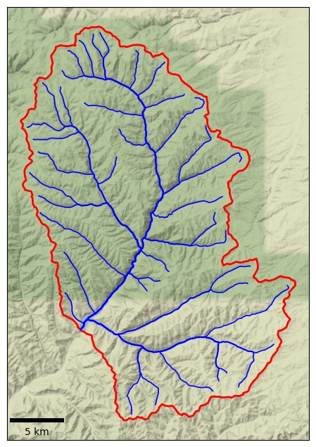
English: Watershed map of the Lost Creek Reservoir in Morgan County, Utah, United States. The major stream channels are shown in blue and the watershed boundary in red. |
| Date | |
| Source | Own work. Data for the watershed boundary and rivers data is from the US Geological Survey, obtained via the Hydro Network Linked Data Index (NLDI). Map created with the Python script described here: https://mghydro.com/?p=58. Map background by Stamen Design, CC BY 3.0. Background data (c) OpenStreetMap contributors. |
| Author | Mheberger |
Licensing
edit
I, the copyright holder of this work, hereby publish it under the following license:
This file is licensed under the Creative Commons Attribution-Share Alike 4.0 International license.
- You are free:
- to share – to copy, distribute and transmit the work
- to remix – to adapt the work
- Under the following conditions:
- attribution – You must give appropriate credit, provide a link to the license, and indicate if changes were made. You may do so in any reasonable manner, but not in any way that suggests the licensor endorses you or your use.
- share alike – If you remix, transform, or build upon the material, you must distribute your contributions under the same or compatible license as the original.
File history
Click on a date/time to view the file as it appeared at that time.
| Date/Time | Thumbnail | Dimensions | User | Comment | |
|---|---|---|---|---|---|
| current | 06:00, 10 February 2023 | | 449 × 636 (96 KB) | Mheberger (talk | contribs) | added scale bar |
| 07:19, 7 February 2023 |  | 493 × 640 (99 KB) | Mheberger (talk | contribs) | Uploaded while editing "Draft:Watershed delineation" on en.wikipedia.org |
You cannot overwrite this file.
File usage on Commons
There are no pages that use this file.
File usage on other wikis
The following other wikis use this file:
- Usage on en.wikipedia.org