File:Louis-François Cassas, Plan général de la ville et des environs de Spalatro (FL147457684 2464170).jpg

Size of this preview: 800 × 599 pixels. Other resolutions: 320 × 240 pixels | 640 × 479 pixels | 1,024 × 767 pixels | 1,280 × 959 pixels | 2,560 × 1,917 pixels | 14,658 × 10,977 pixels.
Original file (14,658 × 10,977 pixels, file size: 228.87 MB, MIME type: image/jpeg)
Captions
Captions
Add a one-line explanation of what this file represents
Summary
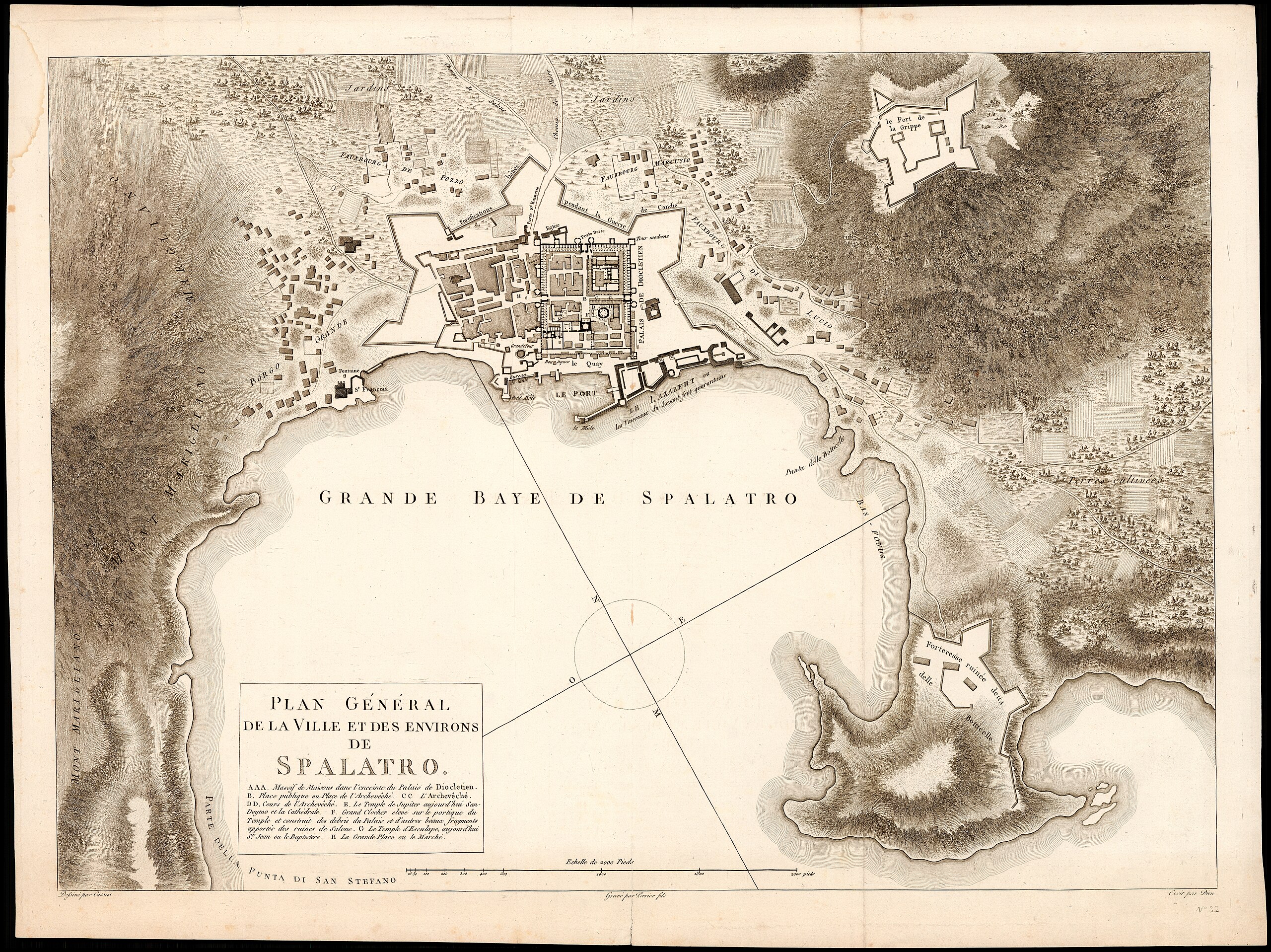
edit| Plan général de la ville et des environs de Spalatro
( |
||||||||||||||||||||||||
|---|---|---|---|---|---|---|---|---|---|---|---|---|---|---|---|---|---|---|---|---|---|---|---|---|
| Artist |
| |||||||||||||||||||||||
| Contributors | Dien Perrier, active 1760-1824 | |||||||||||||||||||||||
| Title |
Plan général de la ville et des environs de Spalatro |
|||||||||||||||||||||||
| Description |
Plan général de la ville et des environs de Spalatro. Dessiné par Cassas ; Gravé par Perrier fils ; Ecrit par Dien. |
|||||||||||||||||||||||
| Language | French | |||||||||||||||||||||||
| Publication date | circa 1840 | |||||||||||||||||||||||
| Medium | 1 map ; | |||||||||||||||||||||||
| Dimensions | height: 405 mm (15.94 in); width: 560 mm (22.04 in) | |||||||||||||||||||||||
| Collection |
|
|||||||||||||||||||||||
| Current location |
|
|||||||||||||||||||||||
| Place of publication | unknown | |||||||||||||||||||||||
| search Merhav catalog | unknown | |||||||||||||||||||||||
| Notes | ||||||||||||||||||||||||
| IE PID | IE147457681 | |||||||||||||||||||||||
| Rosetta filename | FL147457684 | |||||||||||||||||||||||
| NNL item ID (P3959) | 990024641700205171 | |||||||||||||||||||||||
| search Merhav catalog | French, Louis-François Cassas | |||||||||||||||||||||||
| Source/Photographer |
|
|||||||||||||||||||||||
| Other versions | ||||||||||||||||||||||||
| Jpg / Tif version |
|
|||||||||||||||||||||||


.jpg)

.jpg&action=edit§ion=1)
Licensing
edit.jpg&action=edit§ion=2)
The copyright situation of this work is theoretically uncertain, because in the country of origin copyright lasts 70 years after the death of the author, and the date of the author's death is unknown. However, the date of creation of the work was over 120 years ago, and it is thus a reasonable assumption that the copyright has expired (see here for the community discussion). Do not use this template if the date of death of the author is known.
| |
| This file has been identified as being free of known restrictions under copyright law, including all related and neighboring rights. | |
File history
Click on a date/time to view the file as it appeared at that time.
| Date/Time | Thumbnail | Dimensions | User | Comment | |
|---|---|---|---|---|---|
| current | 03:56, 31 July 2023 | | 14,658 × 10,977 (228.87 MB) | Geagea (talk | contribs) | pattypan 22.03 |
You cannot overwrite this file.
File usage on Commons
The following page uses this file:
.jpg&oldid=788529928)