File:Lower section of Cauldron Snout - geograph.org.uk - 1249847.jpg
Size of this preview: 462 × 600 pixels. Other resolutions: 185 × 240 pixels | 493 × 640 pixels.
Original file (493 × 640 pixels, file size: 100 KB, MIME type: image/jpeg)
Captions
Captions
Add a one-line explanation of what this file represents
Summary
edit
| Description |
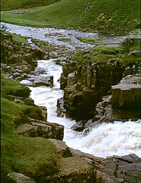
English: Lower section of Cauldron Snout A view down the bottom half of Cauldron Snout to the confluence of the River Tees (which is released into Cauldron Snout from the Cow Green Reservoir dam) with Maize Beck. Unbelievable as it may seem, several people have attempted to kayak down this waterfall and at least one has got all the way down still in his boat. The rating of grade 6 is hardly surprising, but at the right level the river can be run 60m of vertical drop over a very short distance of this fall. |
| Date | |
| Source | From geograph.org.uk |
| Author | Andy Waddington |
| Attribution (required by the license) | Andy Waddington / Lower section of Cauldron Snout / |
| Camera location | | View this and other nearby images on: OpenStreetMap |
|---|
_heading:202.00&language=en)
| Object location | | View this and other nearby images on: OpenStreetMap |
|---|
_heading:202.00&language=en)
Licensing
edit

|
This image was taken from the Geograph project collection. See this photograph's page on the Geograph website for the photographer's contact details. The copyright on this image is owned by Andy Waddington and is licensed for reuse under the Creative Commons Attribution-ShareAlike 2.0 license.
|
This file is licensed under the Creative Commons Attribution-Share Alike 2.0 Generic license.
Attribution: Andy Waddington
- You are free:
- to share – to copy, distribute and transmit the work
- to remix – to adapt the work
- Under the following conditions:
- attribution – You must give appropriate credit, provide a link to the license, and indicate if changes were made. You may do so in any reasonable manner, but not in any way that suggests the licensor endorses you or your use.
- share alike – If you remix, transform, or build upon the material, you must distribute your contributions under the same or compatible license as the original.
File history
Click on a date/time to view the file as it appeared at that time.
| Date/Time | Thumbnail | Dimensions | User | Comment | |
|---|---|---|---|---|---|
| current | 17:01, 26 February 2011 | | 493 × 640 (100 KB) | GeographBot (talk | contribs) | == {{int:filedesc}} == {{Information |description={{en|1=Lower section of Cauldron Snout A view down the bottom half of Cauldron Snout to the confluence of the River Tees (which is released into Cauldron Snout from the Cow Green Reservoir dam) with Maize |
You cannot overwrite this file.
File usage on Commons
There are no pages that use this file.