File:Luberon topographic map-fr.png
Size of this preview: 800 × 425 pixels. Other resolutions: 320 × 170 pixels | 640 × 340 pixels | 1,267 × 673 pixels.
Original file (1,267 × 673 pixels, file size: 1.12 MB, MIME type: image/png)
Captions
Captions
Add a one-line explanation of what this file represents
| Description |
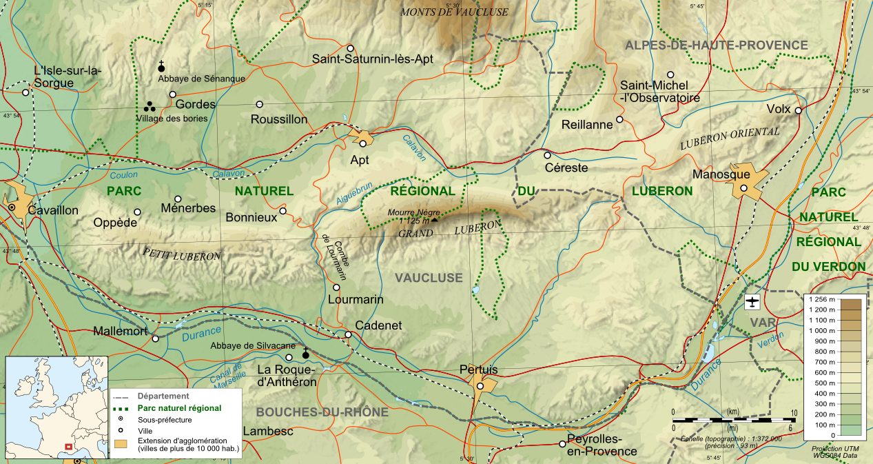
Français : Carte topographique et administrative en français du Luberon (svg original : File:Luberon topographic map-fr.svg) Deutsch: Topographische Karte / Verwaltungskarte zum Luberon, in Französische English: Topographic and administrative map in French of Luberon Español: Mapa topográfico y administrativo en francès del Luberon Italiano: Carta topografica e amministrativa del massiccio del Luberon 日本語: フランス語で表示したLuberonの地形·行政地図 Português: Carta topográfica e da administração do Luberon em francês
|
||
| Date | |||
| Source |
Français : Création personnelle ;
English: Own work ;
|
||
| Author | Bourrichon - fr:Bourrichon | ||
| Permission (Reusing this file) |
I, the copyright holder of this work, hereby publish it under the following licenses:
This file is licensed under the Creative Commons Attribution-Share Alike 3.0 Unported, 2.5 Generic, 2.0 Generic and 1.0 Generic license.
You may select the license of your choice. |
||
| Other versions |
|


File history
Click on a date/time to view the file as it appeared at that time.
| Date/Time | Thumbnail | Dimensions | User | Comment | |
|---|---|---|---|---|---|
| current | 12:47, 10 June 2009 | | 1,267 × 673 (1.12 MB) | Bourrichon (talk | contribs) | {{Information |Description= {{fr|Carte topographique et administrative en français du Luberon (svg original : File:Luberon topographic map-fr.svg)}}{{de|Topographische Karte / Verwaltungskarte zum Luberon, in Französ |
You cannot overwrite this file.
File usage on Commons
The following 5 pages use this file:
File usage on other wikis
The following other wikis use this file:
- Usage on cs.wikipedia.org
- Usage on da.wikipedia.org
- Usage on en.wikipedia.org
- Usage on eo.wikipedia.org
- Usage on es.wikipedia.org
- Usage on fr.wikipedia.org
- Roussillon (Vaucluse)
- Massif du Luberon
- Apt
- Lourmarin
- Sigonce
- Montfuron
- Saint-Michel-l'Observatoire
- Pierrerue (Alpes-de-Haute-Provence)
- Niozelles
- Limans
- Saint-Maime
- Saint-Martin-les-Eaux
- Villeneuve (Alpes-de-Haute-Provence)
- Volx
- Pertuis (Vaucluse)
- Véroncle
- Puget
- Puyvert
- Sannes
- Vaugines
- Villelaure
- Village des bories
- Triangle d'or du Luberon
- Abbaye Saint-Hilaire (Ménerbes)
- Wikipédia:Atelier graphique/Cartes/Archives/juin 2009
- Utilisateur:Bserin/brouillon1/PACA
- Forêt des cèdres du Luberon
- Wikipédia:Atelier graphique/Cartes/Archives/octobre 2010
- Une année en Provence
- Grand Vallat (Calavon)
- Wikipédia:Atelier graphique/Cartes/Archives/juillet 2022
- Usage on he.wikipedia.org
- Usage on nl.wikipedia.org
- Usage on oc.wikipedia.org
- Usage on ru.wikipedia.org