File:Lubochnia (gmina).png

Original file (1,994 × 2,005 pixels, file size: 546 KB, MIME type: image/png)
Captions
Captions
Summary
edit.png&action=edit§ion=1)
| Description |
English: Location map |
| Date | |
| Source | Own work |
| Author | Smat |
| Description |
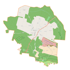
Polski: Mapa gminy Lubochnia, Polska
English: Map of Lubochnia (gmina), Poland |
|||||||||
| Date | ||||||||||
| Source | You may find a page on the OpenStreetMap wiki page for Lubochnia (gmina) | |||||||||
| Creator |
OpenStreetMap contributors OpenStreetMap contributors |
|||||||||
| Permission (Reusing this file) |
OpenStreetMap data is available under the Open Database License (details). Map tiles are licensed under the Creative Commons Attribution-ShareAlike 2.0 license (CC-BY-SA 2.0).
This file is licensed under the Creative Commons Attribution-Share Alike 2.0 Generic license.
|
|||||||||
| Geotemporal data | ||||||||||
| Bounding box |
|
|||||||||
| Georeferencing | If inappropriate please set warp_status = skip to hide. | |||||||||
Licensing
edit.png&action=edit§ion=2)
| This work contains information from OpenStreetMap, which is made available under the Open Database License (ODbL).
The ODbL does not require any particular license for maps produced from ODbL data. Prior to 1 August 2020, map tiles produced by the OpenStreetMap Foundation were licensed under the CC-BY-SA-2.0 license. Maps produced by other people may be subject to other licences. |
File history
Click on a date/time to view the file as it appeared at that time.
| Date/Time | Thumbnail | Dimensions | User | Comment | |
|---|---|---|---|---|---|
| current | 18:45, 22 January 2018 | | 1,994 × 2,005 (546 KB) | Smat (talk | contribs) | User created page with UploadWizard |
You cannot overwrite this file.
File usage on Commons
There are no pages that use this file.
File usage on other wikis
The following other wikis use this file:
- Usage on pl.wikipedia.org
- Brenica (Polska)
- Lubochenek
- Lubochnia-Górki
- Luboszewy
- Małecz
- Nowy Glinnik
- Nowy Jasień
- Lubochnia (województwo łódzkie)
- Tarnowska Wola (województwo łódzkie)
- Emilianów (powiat tomaszowski)
- Glinnik (powiat tomaszowski)
- Henryków (powiat tomaszowski)
- Jakubów (powiat tomaszowski)
- Jasień (powiat tomaszowski)
- Kochanów (powiat tomaszowski)
- Marianka (powiat tomaszowski)
- Olszowiec (powiat tomaszowski)
- Albertów (gmina Lubochnia)
- Dąbrowa (gmina Lubochnia)
- Dębniak (gmina Lubochnia)
- Nowy Olszowiec
- Lubochnia Dworska
- Nowy Glinnik-Osiedle
- Parafia Wniebowzięcia Najświętszej Maryi Panny w Lubochni
- Kierz (województwo łódzkie)
- Rzekietka
- Czółna (województwo łódzkie)
- Kruszewiec (powiat tomaszowski)
- Cygan (województwo łódzkie)
- Chrzemce
- Szczurek (województwo łódzkie)
- Eleonorów
- Rezerwat przyrody Kruszewiec
- Rezerwat przyrody Małecz
- Rezerwat przyrody Starodrzew Lubochniański
- Parafia wojskowa św. Józefa w Nowym Glinniku
- Cmentarz wojenny w Lubochni
- Moduł:Mapa/dane/Lubochnia (gmina)
- Kościół Wniebowzięcia Najświętszej Maryi Panny w Lubochni
- Łąki Ciebłowickie
- Jabłoń (Luboszewy)
- Usage on pl.wikibooks.org
.png&oldid=607600580)