File:Luftaufnahme DLR Köln.jpg

Size of this preview: 424 × 600 pixels. Other resolutions: 170 × 240 pixels | 339 × 480 pixels | 543 × 768 pixels | 724 × 1,024 pixels | 2,480 × 3,508 pixels.
Original file (2,480 × 3,508 pixels, file size: 5.11 MB, MIME type: image/jpeg)
Captions
Captions
Add a one-line explanation of what this file represents
Summary edit
| Description |
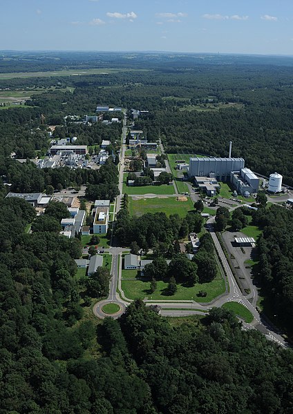
Deutsch: Luftaufnahme des DLR-Standorts Köln mit dem links angrenzenden Gelände des Flughafens Köln/Bonn.
English: Head office of the German Aerospace Center in Lind, Cologne, adjacent to Cologne/Bonn Airport |
| Date | |
| Source | http://www.dlr.de/dlr/desktopdefault.aspx/tabid-10258/314_read-220 |
| Author |
Deutsch: unbekannt/Deutsches Zentrum für Luft- und Raumfahrt English: unknown/German Aerospace Center |
| Camera location | | View this and other nearby images on: OpenStreetMap |
|---|
Licensing edit
| This media has been released under a free license by the Deutsches Zentrum für Luft- und Raumfahrt (DLR). Their website states: "Where expressly stated, DLR images and videos are covered by a Creative Commons Attribution 3.0 Germany (CC BY 3.0) licence. This licence grants permission to reproduce or distribute the work, to make the work and/or its contents publically available, to alter or edit the work and/or its contents and to make commercial use of the work, provided that you explicitly mention DLR as its source in a clearly legible format. Examples: 'Photo: DLR, CC-BY 3.0', 'Images: DLR, CC-BY 3.0', 'Video: DLR, CC-BY 3.0'." To the uploader: You must provide a link (URL) to the original file and the authorship information if available. |
This file is licensed under the Creative Commons Attribution 3.0 Germany license.
Attribution: DLR, CC-BY 3.0
- You are free:
- to share – to copy, distribute and transmit the work
- to remix – to adapt the work
- Under the following conditions:
- attribution – You must give appropriate credit, provide a link to the license, and indicate if changes were made. You may do so in any reasonable manner, but not in any way that suggests the licensor endorses you or your use.

File history
Click on a date/time to view the file as it appeared at that time.
| Date/Time | Thumbnail | Dimensions | User | Comment | |
|---|---|---|---|---|---|
| current | 20:45, 8 September 2012 | | 2,480 × 3,508 (5.11 MB) | Jotpe (talk | contribs) | =={{int:filedesc}}== {{Information |description={{de|1=Luftaufnahme des DLR-Standorts Köln mit dem links angrenzenden Gelände des Flughafens Köln/Bonn.}} |date=2010-08-20 13:23 |source=http://www.dlr.de/dlr/desktopdefault.aspx/tabid-10258/314_read-... |
You cannot overwrite this file.
File usage on Commons
The following 2 pages use this file:
File usage on other wikis
The following other wikis use this file:
- Usage on ast.wikipedia.org
- Usage on be.wikipedia.org
- Usage on ca.wikipedia.org
- Usage on cs.wikipedia.org
- Usage on de.wikipedia.org
- Usage on en.wikipedia.org
- Usage on eo.wikipedia.org
- Usage on es.wikipedia.org
- Usage on gl.wikipedia.org
- Usage on he.wikipedia.org
- Usage on it.wikipedia.org
- Usage on no.wikipedia.org
- Usage on ru.wikipedia.org
- Usage on ru.wikinews.org
- Usage on sk.wikipedia.org
- Usage on tr.wikipedia.org
- Usage on vi.wikipedia.org
- Usage on www.wikidata.org
- Usage on zh.wikipedia.org