File:Luftaufnahme Olymp.jpg

Size of this preview: 800 × 600 pixels. Other resolutions: 320 × 240 pixels | 640 × 480 pixels | 1,000 × 750 pixels.
Original file (1,000 × 750 pixels, file size: 189 KB, MIME type: image/jpeg)
Captions
Captions
Add a one-line explanation of what this file represents
Summary edit
| Description |
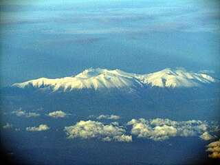
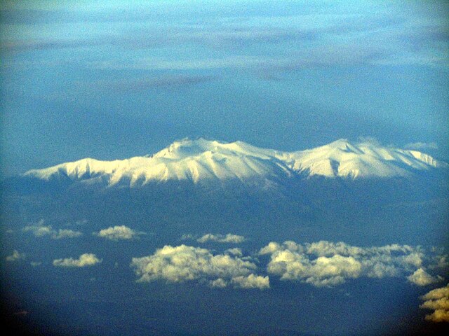
English: Aerial View of Mount Olympus
Deutsch: Luftaufnahme vom Olymp |
| Date | |
| Source | Own work |
| Author | RThiele |
| Camera location | | View this and other nearby images on: OpenStreetMap |
|---|
Aufnahmeposition 39°22'9.99"N 21°16'56.68"E Zielposition 40°6'57.20"N 22°25'23.14"E Aufnahme aus Pssagierflugzeug 11500 n hoch, 120 km Distanz
Licensing edit
I, the copyright holder of this work, hereby publish it under the following license:
This file is licensed under the Creative Commons Attribution-Share Alike 3.0 Unported license.
- You are free:
- to share – to copy, distribute and transmit the work
- to remix – to adapt the work
- Under the following conditions:
- attribution – You must give appropriate credit, provide a link to the license, and indicate if changes were made. You may do so in any reasonable manner, but not in any way that suggests the licensor endorses you or your use.
- share alike – If you remix, transform, or build upon the material, you must distribute your contributions under the same or compatible license as the original.
File history
Click on a date/time to view the file as it appeared at that time.
| Date/Time | Thumbnail | Dimensions | User | Comment | |
|---|---|---|---|---|---|
| current | 14:08, 21 April 2011 | | 1,000 × 750 (189 KB) | RThiele (talk | contribs) | {{Information |Description ={{en|1=Aerial View of Mount Olympus}} {{de|1=Luftaufnahme vom Olymp}} |Source ={{own}} |Author =RThiele |Date =2011-03-23 |Permission = |other_versions = }} Aufnahmeposition 39 |
You cannot overwrite this file.
File usage on Commons
There are no pages that use this file.
File usage on other wikis
The following other wikis use this file:
- Usage on de.wikipedia.org