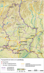
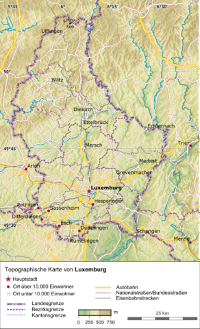
File:Luxemburg Topographisch.png

Size of this preview: 364 × 599 pixels. Other resolutions: 146 × 240 pixels | 292 × 480 pixels | 467 × 768 pixels | 1,216 × 2,000 pixels.
Original file (1,216 × 2,000 pixels, file size: 3.56 MB, MIME type: image/png)
Captions
Captions
Add a one-line explanation of what this file represents
| Description |
Deutsch: Topographische Karte von Luxemburg |
|||
| Date | ||||
| Source |
Own work, using:
|
|||
| Author | Carport | |||
| Permission (Reusing this file) |
This file is licensed under the Creative Commons Attribution-Share Alike 3.0 Unported license.
|
File history
Click on a date/time to view the file as it appeared at that time.
| Date/Time | Thumbnail | Dimensions | User | Comment | |
|---|---|---|---|---|---|
| current | 13:40, 15 December 2012 | | 1,216 × 2,000 (3.56 MB) | Carport (talk | contribs) | {{Information |Description={{de|Topographische Karte von {{w|Luxemburg|3=de}}}} |Source={{own}}, using: * OpenStreetMap data * SRTM-3 data for the background * The {{w|Generic Mapping Tools}} for geocoding |Date=2012-12-15 |Author={{u|Carport}} |Pe... |
You cannot overwrite this file.
File usage on Commons
The following page uses this file:
File usage on other wikis
The following other wikis use this file:
- Usage on de.wikipedia.org
- Usage on rm.wikipedia.org
- Usage on uk.wikipedia.org
- Usage on zea.wikipedia.org