File:Mětikalov, historická ortofotomapa (50. léta).jpg

Size of this preview: 606 × 600 pixels. Other resolutions: 243 × 240 pixels | 485 × 480 pixels | 776 × 768 pixels | 1,037 × 1,026 pixels.
Original file (1,037 × 1,026 pixels, file size: 503 KB, MIME type: image/jpeg)
Captions
Captions
Add a one-line explanation of what this file represents
Summary edit
.jpg&action=edit§ion=1)
| Description |
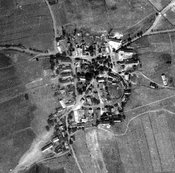
Čeština: Dnes již zaniklá vesnice Mětikalov (vojenský újezd Hradiště) |
| Date | between 1952 and 1954 |
| Source | https://micka.cenia.cz/record/basic/50210752-9d9c-4f47-956b-1951c0a80137 |
| Author | Historická ortofotomapa © CENIA 2010 a © GEODIS Brno, spol. s r.o. 2010 Podkladové letecké snímky poskytl VGHMÚř Dobruška, © MO ČR 2009. |
| Camera location | | View this and other nearby images on: OpenStreetMap |
|---|
.jpg¶ms=050.222563_N_0013.184039_E_globe:Earth_type:camera__&language=en)
Licensing edit
.jpg&action=edit§ion=2)
This file is licensed under the Creative Commons Attribution 4.0 International license.
- You are free:
- to share – to copy, distribute and transmit the work
- to remix – to adapt the work
- Under the following conditions:
- attribution – You must give appropriate credit, provide a link to the license, and indicate if changes were made. You may do so in any reasonable manner, but not in any way that suggests the licensor endorses you or your use.
File history
Click on a date/time to view the file as it appeared at that time.
| Date/Time | Thumbnail | Dimensions | User | Comment | |
|---|---|---|---|---|---|
| current | 20:02, 22 March 2024 | | 1,037 × 1,026 (503 KB) | Hubert Kororo (talk | contribs) | Uploaded a work by Historická ortofotomapa © CENIA 2010 a © GEODIS Brno, spol. s r.o. 2010 Podkladové letecké snímky poskytl VGHMÚř Dobruška, © MO ČR 2009. from https://micka.cenia.cz/record/basic/50210752-9d9c-4f47-956b-1951c0a80137 with UploadWizard |
You cannot overwrite this file.
File usage on Commons
There are no pages that use this file.
File usage on other wikis
The following other wikis use this file:
.jpg&oldid=862667226)