File:MAPPA LONGOBARDI.jpg

Size of this preview: 482 × 599 pixels. Other resolutions: 193 × 240 pixels | 386 × 480 pixels | 754 × 937 pixels.
Original file (754 × 937 pixels, file size: 145 KB, MIME type: image/jpeg)
Captions
Captions
Add a one-line explanation of what this file represents
Summary
edit
| Description |
|
| Date | |
| Source | Own work |
| Author | Enryonthecloud |
Licensing
edit
| I, the copyright holder of this work, release this work into the public domain. This applies worldwide. In some countries this may not be legally possible; if so: I grant anyone the right to use this work for any purpose, without any conditions, unless such conditions are required by law. |
File history
Click on a date/time to view the file as it appeared at that time.
| Date/Time | Thumbnail | Dimensions | User | Comment | |
|---|---|---|---|---|---|
| current | 12:48, 11 September 2017 | | 754 × 937 (145 KB) | Enryonthecloud (talk | contribs) | Più dati e chiarezza nei contenuti. |
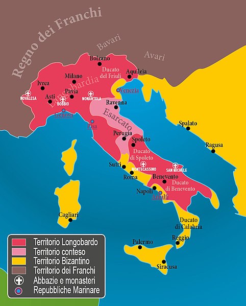
| 08:56, 11 September 2017 |  | 714 × 918 (142 KB) | Enryonthecloud (talk | contribs) | {{Informazioni file |Descrizione = Mappa della penisola italica intorno all'anno 590 |Fonte = opera propria |Data = settembre 2017 |Autore = Enryonthecloud |Licenza = vedi sotto |Detentore copyright = vedi sotto |EDP = |Altre versioni = }} |
You cannot overwrite this file.
File usage on Commons
There are no pages that use this file.
File usage on other wikis
The following other wikis use this file:
- Usage on it.wikipedia.org