File:MBTA Commuter Rail map 2010.png
Size of this preview: 600 × 600 pixels. Other resolutions: 240 × 240 pixels | 480 × 480 pixels | 768 × 768 pixels | 1,024 × 1,024 pixels | 1,667 × 1,667 pixels.
Original file (1,667 × 1,667 pixels, file size: 440 KB, MIME type: image/png)
Captions
Captions
Add a one-line explanation of what this file represents
Summary
edit| Description |
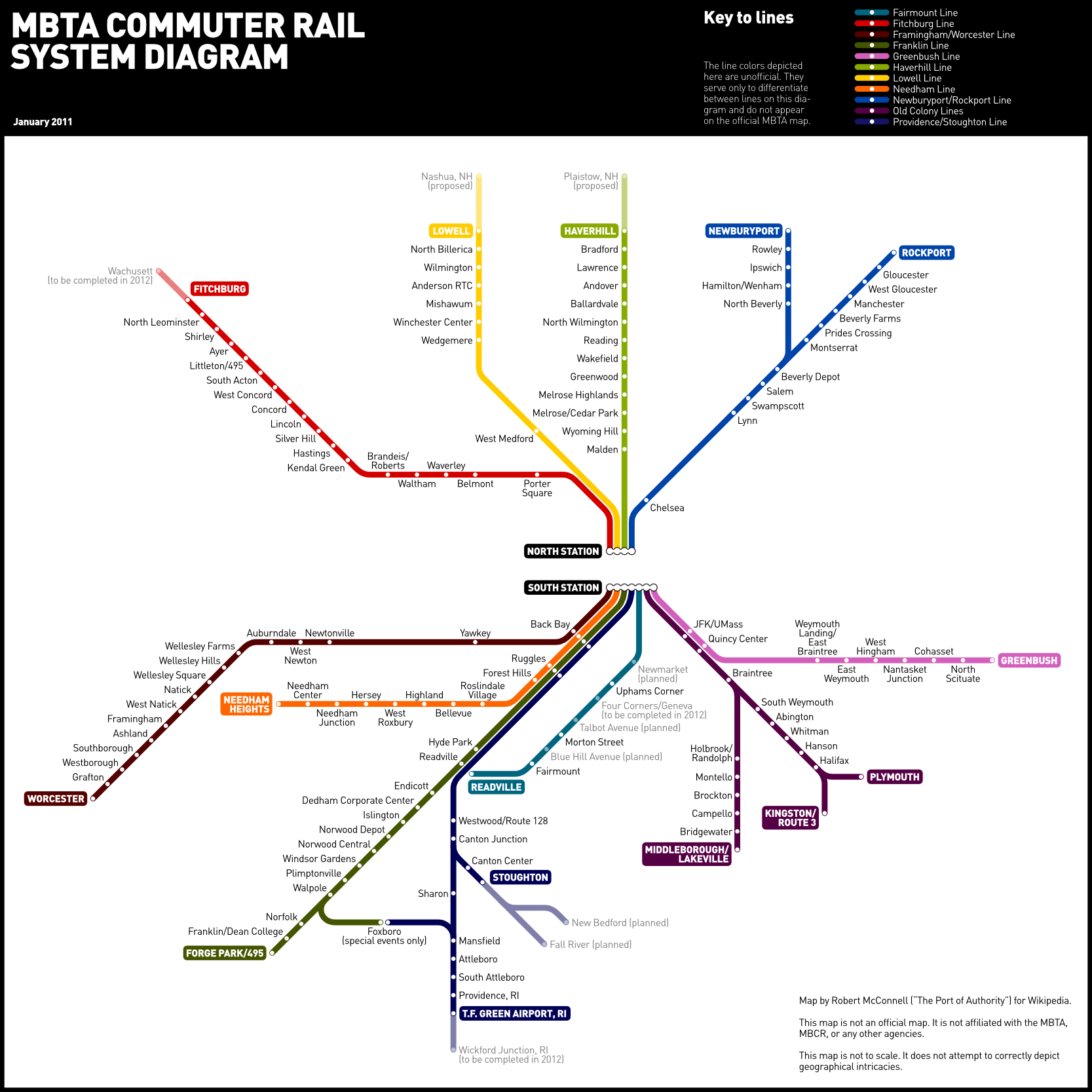
English: Schematic map of the MBTA Commuter Rail system, accurate to the opening of T.F. Green Airport station in December 2010 and future plans at that date. More recent openings and plans are not shown.
|
|||
| Date | ||||
| Source | Own work | |||
| Author | Robert McConnell (The Port of Authority at English Wikipedia) created the original version. Modifications to the earlier version were made by Grk1011 and Schzmo at English Wikipedia. |


Licensing
edit
The Port of Authority at en.wikipedia, the copyright holder of this work, hereby publishes it under the following licenses:
This file is licensed under the Creative Commons Attribution-Share Alike 3.0 Unported license.
Attribution: The Port of Authority at en.wikipedia
- You are free:
- to share – to copy, distribute and transmit the work
- to remix – to adapt the work
- Under the following conditions:
- attribution – You must give appropriate credit, provide a link to the license, and indicate if changes were made. You may do so in any reasonable manner, but not in any way that suggests the licensor endorses you or your use.
- share alike – If you remix, transform, or build upon the material, you must distribute your contributions under the same or compatible license as the original.

|
Permission is granted to copy, distribute and/or modify this document under the terms of the GNU Free Documentation License, Version 1.2 or any later version published by the Free Software Foundation; with no Invariant Sections, no Front-Cover Texts, and no Back-Cover Texts. A copy of the license is included in the section entitled GNU Free Documentation License. |
You may select the license of your choice.
Original upload log
edit
The original description page was here. All following user names refer to en.wikipedia.
- 2011-01-15 19:09 The Port of Authority 1667×1667× (450317 bytes) Changed "Haverhill/Reading Line" to "Haverhill Line"; fixed the status of Blue Hill Avenue station on the Fairmount Line.
- 2011-01-15 18:34 The Port of Authority 1667×1667× (452154 bytes) Corrected the location of Mansfield station on the Providence-Stoughton line.
- 2011-01-15 01:05 The Port of Authority 1667×1667× (452314 bytes) Redrew diagram more realistically and added planned, proposed and under-construction stations.
- 2010-12-17 23:50 Grk1011 1060×1076× (280745 bytes) TF Green now open
- 2010-10-04 00:01 Grk1011 1060×1076× (281684 bytes) fix Yawkey station as it has been open daily since 2001.
- 2010-10-03 17:41 Grk1011 1060×1076× (283270 bytes) further update status of proposed and under construction
- 2010-10-02 20:48 Grk1011 1060×1040× (248638 bytes) Plaistow is an extension of the Haverhill Line, not Lowell. Probably messed up the PNGness, but at least it is more accurate.
- 2009-07-27 22:25 Schzmo 1060×1040× (221686 bytes) Added Forest Hills
- 2009-07-13 15:22 The Port of Authority 1060×1040× (321445 bytes) {{Information |Description = Schematic map of the [[MBTA Commuter Rail]] system. |Source = self-made |Date = 2009.07.13 |Author = ~~~ |other_versions = }}
File history
Click on a date/time to view the file as it appeared at that time.
| Date/Time | Thumbnail | Dimensions | User | Comment | |
|---|---|---|---|---|---|
| current | 21:48, 17 October 2011 | | 1,667 × 1,667 (440 KB) | File Upload Bot (Magnus Manske) (talk | contribs) | {{BotMoveToCommons|en.wikipedia|year={{subst:CURRENTYEAR}}|month={{subst:CURRENTMONTHNAME}}|day={{subst:CURRENTDAY}}}} {{Information |Description={{en|Schematic map of the en:MBTA Commuter Rail system.}} |Source=Transferred from [http://en.wikipedi |
You cannot overwrite this file.
File usage on Commons
The following page uses this file:
- File:MBTA Commuter Rail map.png (file redirect)