File:MGRSgridSouthPole.png

Size of this preview: 798 × 600 pixels. Other resolutions: 320 × 240 pixels | 639 × 480 pixels | 1,022 × 768 pixels | 1,280 × 962 pixels | 1,469 × 1,104 pixels.
Original file (1,469 × 1,104 pixels, file size: 1,023 KB, MIME type: image/png)
Captions
Captions
Add a one-line explanation of what this file represents
Summary
edit
| Description |
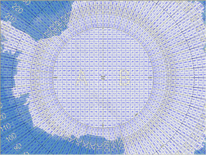
English: Map of the Military Grid Reference System (MGRS) around the South Pole, with the AA lettering scheme for the 100 km squares north of 80°S. |
| Date | |
| Source |
English: Mikael R made the MGRS grid in Carmenta Engine, with a background map from Natural Earth by Tom Patterson, US National Park Service. |
| Author | Mikael Rittri (MikaelR) |
Licensing
edit
This file is licensed under the Creative Commons Attribution-Share Alike 3.0 Unported license.
- You are free:
- to share – to copy, distribute and transmit the work
- to remix – to adapt the work
- Under the following conditions:
- attribution – You must give appropriate credit, provide a link to the license, and indicate if changes were made. You may do so in any reasonable manner, but not in any way that suggests the licensor endorses you or your use.
- share alike – If you remix, transform, or build upon the material, you must distribute your contributions under the same or compatible license as the original.
File history
Click on a date/time to view the file as it appeared at that time.
| Date/Time | Thumbnail | Dimensions | User | Comment | |
|---|---|---|---|---|---|
| current | 11:59, 21 November 2007 | | 1,469 × 1,104 (1,023 KB) | MikaelR (talk | contribs) | {{Information |Description={{en|Map of the Military Grid Reference System (MGRS) around the South Pole, with the AA lettering scheme for the 100 km squares north of 80°S.}} |Source={{en|Mikael R made the MGRS grid in SpatialAce of Carmenta, with a backgr |
You cannot overwrite this file.
File usage on Commons
There are no pages that use this file.
File usage on other wikis
The following other wikis use this file:
- Usage on en.wikipedia.org
- Usage on fi.wikipedia.org
- Usage on uk.wikipedia.org
- Usage on zh.wikipedia.org