File:MINISTRO VALAKIVI VISITÓ EL FUTURO CENTRO DE OPERACIONES DE IMÁGENES SATELITALES EN PUCUSANA (19207286080).jpg

Original file (5,472 × 3,648 pixels, file size: 6.5 MB, MIME type: image/jpeg)
Captions
Captions
Summary
edit.jpg&action=edit§ion=1)
| Description |
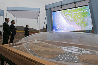
El Ministro de Defensa Jakke Valakivi encabezó la primera visita oficial a la sede donde se construirá el moderno Centro Nacional de Operaciones de Imágenes Satelitales (CNOIS) en Punta Lobos, Pucusana, infraestructura soporte del primer Satélite de Observación Terrestre adquirido por el Perú. El ministro estuvo acompañado del enviado personal del presidente de la República Francesa para América Latina, Jean Pierre Bel, con quien colocó el bloque recordatorio de la visita. Asimismo, participaron el embajador de este país en el Perú, Fabrice Maurice; el Jefe del Comando Conjunto de las Fuerzas Armadas, Almirante Jorge Moscoso, y los comandantes generales de la Fuerza Aérea y Ejército del Perú. El Satélite será lanzado el 2016 y fue adquirido mediante mecanismo de gobierno a gobierno a Francia. Aportará numerosos beneficios en desarrollo, crecimiento y seguridad, y coloca al país a la vanguardia de la tecnología espacial en la región. Se tratará del primer Satélite Submétrico en Latinoamérica y captará imágenes con detalle inferior a un metro desde la superficie para transmitirlas de manera encriptada en horas a la estación terrena de Punta Lobos. Con ello se fortalecerá la prevención y respuesta frente a desastres naturales, sismos, combate a la minería ilegal, pesca ilegal, deforestación y todo tipo de ilícitos. Los sectores público y privado podrán acceder a esta información. El Perú tiene el beneficio de acceder a imágenes de seis satélites de países líderes en el ámbito espacial mundial. Asimismo, transferencia tecnológica offset y capacitación para profesionales peruanos, proceso que es liderado por la Comisión de Investigación y Desarrollo Aeroespacial, CONIDA, de la Fuerza Aérea del Perú. |
| Date | |
| Source | MINISTRO VALAKIVI VISITÓ EL FUTURO CENTRO DE OPERACIONES DE IMÁGENES SATELITALES EN PUCUSANA |
| Author | Galeria del Ministerio de Defensa del Perú |
Licensing
edit.jpg&action=edit§ion=2)
- You are free:
- to share – to copy, distribute and transmit the work
- to remix – to adapt the work
- Under the following conditions:
- attribution – You must give appropriate credit, provide a link to the license, and indicate if changes were made. You may do so in any reasonable manner, but not in any way that suggests the licensor endorses you or your use.
| This image was originally posted to Flickr by Galeria del Ministerio de Defensa del Perú at https://flickr.com/photos/92793865@N07/19207286080. It was reviewed on 30 March 2016 by FlickreviewR and was confirmed to be licensed under the terms of the cc-by-2.0. |
File history
Click on a date/time to view the file as it appeared at that time.
| Date/Time | Thumbnail | Dimensions | User | Comment | |
|---|---|---|---|---|---|
| current | 02:39, 30 March 2016 | | 5,472 × 3,648 (6.5 MB) | Tm (talk | contribs) | Transferred from Flickr via Flickr2Commons |
You cannot overwrite this file.
File usage on Commons
There are no pages that use this file.
.jpg&oldid=875330751)