File:MPD 60 near Cloghan Point (geograph 3771976).jpg

Size of this preview: 789 × 600 pixels. Other resolutions: 316 × 240 pixels | 632 × 480 pixels | 1,010 × 768 pixels | 1,268 × 964 pixels.
Original file (1,268 × 964 pixels, file size: 1,019 KB, MIME type: image/jpeg)
Captions
Captions
Add a one-line explanation of what this file represents
Summary
edit.jpg&action=edit§ion=1)
| Description |
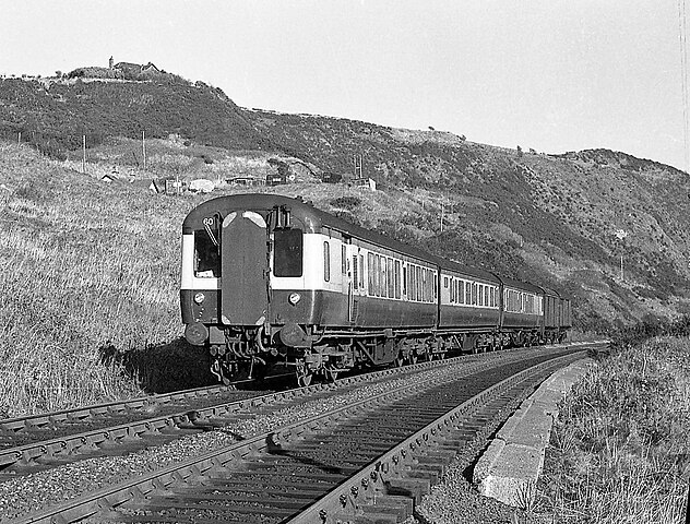
English: MPD 60 near Cloghan Point Long before the oil terminal for Kilroot power station was built, there was a public path beside the railway line from Whitehead to Cloghan Point. Ulster Transport Authority built MPD No. 60 heads a Larne Harbour - Belfast (York Road) passenger service near Cloghan. Note the two "brown vans", built by the UTA and used to convey parcels and mail. |
| Date | |
| Source | From geograph.org.uk |
| Author | The Carlisle Kid |
| Permission (Reusing this file) |
Creative Commons Attribution Share-alike license 2.0 |
| Attribution (required by the license) | The Carlisle Kid / MPD 60 near Cloghan Point / |
| Camera location | | View this and other nearby images on: OpenStreetMap |
|---|
.jpg¶ms=054.740322_N_-005.722453_E_globe:Earth_type:camera_source:geograph-irishgrid(J46739042)_heading:22.00&language=en)
| Object location | | View this and other nearby images on: OpenStreetMap |
|---|
.jpg¶ms=054.741030_N_-005.721790_E_globe:Earth_class:object_type:object_source:geograph-irishgrid(J46779050)_heading:22.00&language=en)
Licensing
edit.jpg&action=edit§ion=2)

|
This image was taken from the Geograph project collection. See this photograph's page on the Geograph website for the photographer's contact details. The copyright on this image is owned by The Carlisle Kid and is licensed for reuse under the Creative Commons Attribution-ShareAlike 2.0 license.
|
This file is licensed under the Creative Commons Attribution-Share Alike 2.0 Generic license.
Attribution: The Carlisle Kid
- You are free:
- to share – to copy, distribute and transmit the work
- to remix – to adapt the work
- Under the following conditions:
- attribution – You must give appropriate credit, provide a link to the license, and indicate if changes were made. You may do so in any reasonable manner, but not in any way that suggests the licensor endorses you or your use.
- share alike – If you remix, transform, or build upon the material, you must distribute your contributions under the same or compatible license as the original.
File history
Click on a date/time to view the file as it appeared at that time.
| Date/Time | Thumbnail | Dimensions | User | Comment | |
|---|---|---|---|---|---|
| current | 12:58, 13 March 2022 | | 1,268 × 964 (1,019 KB) | Lamberhurst (talk | contribs) | == {{int:filedesc}} == {{Information |Description={{en|1=<b>MPD 60 near Cloghan Point</b><br>Long before the oil terminal for Kilroot power station was built, there was a public path beside the railway line from Whitehead to Cloghan Point. Ulster Transport Authority built MPD No. 60 heads a Larne Harbour - Belfast (York Road) passenger service near Cloghan. Note the two "brown vans", built by the UTA and used to convey parcels and mail.}} |Source=From [https://www.geograph.org.uk/photo/377197... |
You cannot overwrite this file.
File usage on Commons
The following page uses this file:
.jpg&oldid=638241309)