File:M 7.8 - 105 km SSE of Perryville, Alaska - ShakeMap.jpg
Size of this preview: 486 × 600 pixels. Other resolutions: 194 × 240 pixels | 389 × 480 pixels | 803 × 991 pixels.
Original file (803 × 991 pixels, file size: 212 KB, MIME type: image/jpeg)
Captions
Captions
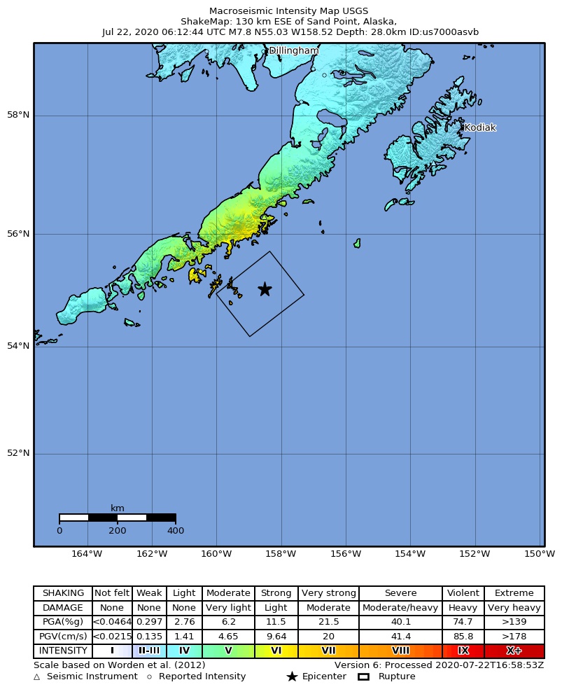
2020 Alaska Peninsula Earthquake - ShakeMap
Summary
edit
| Description |
中文:2020年阿拉斯加地震烈度图
English: M 7.8 - 105 km SSE of Perryville, Alaska - ShakeMap |
| Date | |
| Source | https://earthquake.usgs.gov/earthquakes/eventpage/us7000asvb/shakemap/intensity |
| Author | United States Geological Survey |
Licensing
edit
This image is in the public domain in the United States because it only contains materials that originally came from the United States Geological Survey, an agency of the United States Department of the Interior. For more information, see the official USGS copyright policy.
|
File history
Click on a date/time to view the file as it appeared at that time.
| Date/Time | Thumbnail | Dimensions | User | Comment | |
|---|---|---|---|---|---|
| current | 11:48, 23 July 2020 | | 803 × 991 (212 KB) | Theodore Xu (talk | contribs) | Uploaded a work by United States Geological Survey from https://earthquake.usgs.gov/earthquakes/eventpage/us7000asvb/shakemap/intensity with UploadWizard |
You cannot overwrite this file.
File usage on Commons
The following page uses this file:
File usage on other wikis
The following other wikis use this file:
- Usage on es.wikipedia.org
- Usage on zh.wikipedia.org