File:Ma-On 2011-07-15 0632Z.jpg

Size of this preview: 800 × 450 pixels. Other resolutions: 320 × 180 pixels | 640 × 360 pixels | 1,024 × 576 pixels | 1,280 × 720 pixels | 1,920 × 1,080 pixels.
Original file (1,920 × 1,080 pixels, file size: 1.74 MB, MIME type: image/jpeg)
Captions
Captions
Add a one-line explanation of what this file represents
Summary
edit| Description |
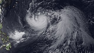
English: Powerful Typhoon Ma-On is a slow moving storm forecast to parallel the eastern coast of Japan starting around July 19, 2011. The storm is northwest of Guam and the Mariana Islands in this image, on a due west heading. Starting July 16, Ma-On will begin to track northwestward, turning northeastward by July 19 as it approaches eastern Japan. To the southwest of Ma-On is Tropical Depression 09W (Tokage) which is not expected to strengthen as it moves northeast. This image was taken by MTSAT-2R at 0632Z July 15, 2011. |
| Date | |
| Source | https://www.nnvl.noaa.gov/MediaDetail2.php?MediaID=779&MediaTypeID=1 |
| Author | JMA |
Licensing
editThis image was produced by the Japan Meteorological Agency. The legal notice (archive) stated that all the images published on their website is compatible with the Creative Commons Attribution 4.0 License, which means that all the images on this website is published under the Creative Commons Attribution 4.0 License unless otherwise specified.
This file is licensed under the Creative Commons Attribution 4.0 International license. Attribution: Japan Meteorological Agency
|
 |

File history
Click on a date/time to view the file as it appeared at that time.
| Date/Time | Thumbnail | Dimensions | User | Comment | |
|---|---|---|---|---|---|
| current | 03:01, 22 April 2018 | | 1,920 × 1,080 (1.74 MB) | A1Cafel (talk | contribs) | User created page with UploadWizard |
You cannot overwrite this file.
File usage on Commons
There are no pages that use this file.