File:Maadilocation.gif
No higher resolution available.
Maadilocation.gif (533 × 572 pixels, file size: 14 KB, MIME type: image/gif)
Captions
Captions
Add a one-line explanation of what this file represents
Summary
edit
| Description |
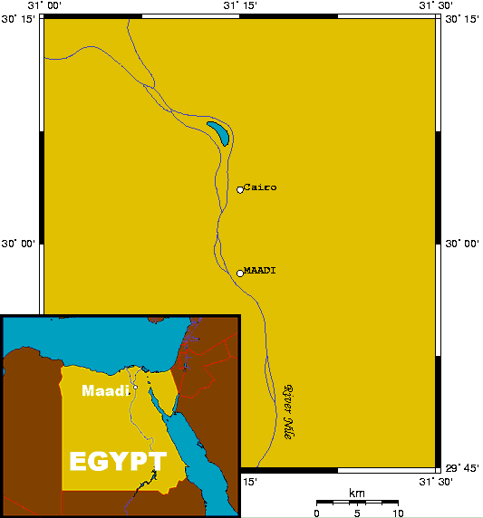
English: Maadi's location, small-scale map to show location relative to Cairo, and large-scale inset. This map's source is here, with the uploader's modifications, and the GMT homepage says that the tools are released under the GNU General Public License, and it may be considered PD. |
| Date | 13 February 2005 (original upload date) |
| Source | Transferred from en.wikipedia to Commons by Man77. |
| Author | Kelisi at English Wikipedia |
Licensing
edit
| This work has been released into the public domain by its author, Kelisi at English Wikipedia. This applies worldwide. In some countries this may not be legally possible; if so: Kelisi grants anyone the right to use this work for any purpose, without any conditions, unless such conditions are required by law. |
Original upload log
edit
The original description page was here. All following user names refer to en.wikipedia.
- 2005-02-13 20:33 Kelisi 533×572×8 (13831 bytes) Maadi's location, small-scale map to show location relative to Cairo, and large-scale inset. This map was generated using OMC, and may be considered PD.
File history
Click on a date/time to view the file as it appeared at that time.
| Date/Time | Thumbnail | Dimensions | User | Comment | |
|---|---|---|---|---|---|
| current | 19:54, 31 March 2008 | | 533 × 572 (14 KB) | File Upload Bot (Magnus Manske) (talk | contribs) | {{BotMoveToCommons|en.wikipedia}} {{Information |Description={{en|Maadi's location, small-scale map to show location relative to Cairo, and large-scale inset. This map's source is [http://www.aquarius.ifm-geomar.de/ here], with the uploader's modificatio |
You cannot overwrite this file.
File usage on Commons
The following page uses this file:
File usage on other wikis
The following other wikis use this file:
- Usage on ar.wikipedia.org
- Usage on arz.wikipedia.org
- Usage on azb.wikipedia.org
- Usage on ca.wikipedia.org
- Usage on de.wikipedia.org
- Usage on en.wikipedia.org
- Usage on eo.wikipedia.org
- Usage on fa.wikipedia.org
- Usage on fr.wikipedia.org
- Usage on ga.wikipedia.org
- Usage on it.wikipedia.org
- Usage on pt.wikipedia.org
- Usage on ru.wikipedia.org
- Usage on sr.wikipedia.org
- Usage on ur.wikipedia.org
- Usage on www.wikidata.org
- Usage on zh.wikipedia.org