File:Macroseismic Intensity Map USGS ShakeMap 18 km SSW of Hualien City, Taiwan, TW Apr 02, 2024 M7.4.pdf

Size of this JPG preview of this PDF file: 472 × 599 pixels. Other resolutions: 189 × 240 pixels | 378 × 480 pixels | 605 × 768 pixels | 1,231 × 1,562 pixels.
Original file (1,231 × 1,562 pixels, file size: 2.21 MB, MIME type: application/pdf)
Captions
Captions
Add a one-line explanation of what this file represents
Summary
edit| Description |
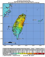
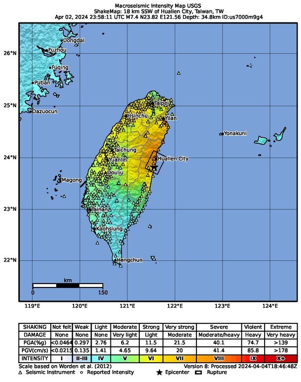
English: Macroseismic Intensity Map USGS
ShakeMap: 18 km SSW of Hualien City, Taiwan, TW Apr 02, 2024 23:58:11 UTC M7.4 N23.82 E121.56 Depth: 34.8km ID:us7000m9g4 |
| Date | |
| Source | https://earthquake.usgs.gov/product/shakemap/us7000m9g4/us/1715297585708/download/intensity.pdf |
| Author | United States Geological Survey |
Most up-to-date maps:
https://earthquake.usgs.gov/earthquakes/eventpage/us7000m9g4/shakemap/intensity
Licensing
editThis image is in the public domain in the United States because it only contains materials that originally came from the United States Geological Survey, an agency of the United States Department of the Interior. For more information, see the official USGS copyright policy.
|
File history
Click on a date/time to view the file as it appeared at that time.
| Date/Time | Thumbnail | Dimensions | User | Comment | |
|---|---|---|---|---|---|
| current | 03:20, 4 June 2024 |  | 1,231 × 1,562 (2.21 MB) | Sapiann (talk | contribs) | Version 11: Processed 2024-05-09T23:30:30Z |
| 02:25, 5 April 2024 |  | 1,231 × 1,562 (2.21 MB) | Sapiann (talk | contribs) | Version 8: Processed 2024-04-04T18:46:48Z | |
| 00:39, 4 April 2024 |  | 1,231 × 1,562 (2.2 MB) | Sapiann (talk | contribs) | Version 7: Processed 2024-04-03T23:59:54Z | |
| 04:03, 3 April 2024 |  | 1,231 × 1,562 (2.2 MB) | Sapiann (talk | contribs) | Uploaded a work by United States Geological Survey from https://earthquake.usgs.gov/realtime/product/shakemap/us7000m9g4/us/1712110164529/download/intensity.pdf with UploadWizard |
You cannot overwrite this file.
File usage on Commons
There are no pages that use this file.
File usage on other wikis
The following other wikis use this file:
- Usage on ar.wikipedia.org
- Usage on en.wikipedia.org
- Usage on es.wikipedia.org
- Usage on fr.wikipedia.org
- Usage on he.wikipedia.org
- Usage on hy.wikipedia.org
- Usage on id.wikipedia.org
- Usage on nl.wikipedia.org
- Usage on pa.wikipedia.org
- Usage on pnb.wikipedia.org
- Usage on pt.wikipedia.org
- Usage on th.wikipedia.org
- Usage on ur.wikipedia.org
- Usage on vi.wikipedia.org
- Usage on zh-min-nan.wikipedia.org
- Usage on zh.wikipedia.org