File:Main-Tauber-Kreis Weikersheim Marktplatz Fußgängerzone.jpg
![File:Main-Tauber-Kreis Weikersheim Marktplatz Fußgängerzone.jpg](https://upload.wikimedia.org/wikipedia/commons/thumb/0/09/Main-Tauber-Kreis_Weikersheim_Marktplatz_Fu%C3%9Fg%C3%A4ngerzone.jpg/800px-Main-Tauber-Kreis_Weikersheim_Marktplatz_Fu%C3%9Fg%C3%A4ngerzone.jpg?20160905131733)
Original file (6,000 × 4,000 pixels, file size: 13.47 MB, MIME type: image/jpeg)
Captions
Captions
Summary
editDescriptionMain-Tauber-Kreis Weikersheim Marktplatz Fußgängerzone.jpg |
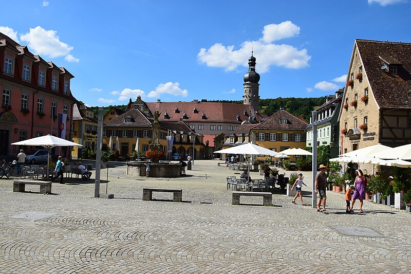
Deutsch: Blick über den Marktplatz in Weikersheim im Main-Tauber-Kreis, Deutschland. Rechts das Gebäude Nr. 8, heute als Museumsgebäude des "Tauberländer Dorfmuseums" genutzt. Links das gebäude Nr. 7 ehemaliges Dekanat, heute Rathaus. Im Hintergrund Schloss Weikersheim, in der Mitte der Marktbrunnen. |
Date | |
Source | Own work |
Author | MSeses |
Camera location | 49° 28′ 50.41″ N, 9° 53′ 52.87″ E ![]() | View this and other nearby images on: OpenStreetMap | ![]() |
---|
Licensing
edit![w:en:Creative Commons](https://upload.wikimedia.org/wikipedia/commons/thumb/7/79/CC_some_rights_reserved.svg/90px-CC_some_rights_reserved.svg.png)
![attribution](https://upload.wikimedia.org/wikipedia/commons/thumb/1/11/Cc-by_new_white.svg/24px-Cc-by_new_white.svg.png)
![share alike](https://upload.wikimedia.org/wikipedia/commons/thumb/d/df/Cc-sa_white.svg/24px-Cc-sa_white.svg.png)
- You are free:
- to share – to copy, distribute and transmit the work
- to remix – to adapt the work
- Under the following conditions:
- attribution – You must give appropriate credit, provide a link to the license, and indicate if changes were made. You may do so in any reasonable manner, but not in any way that suggests the licensor endorses you or your use.
- share alike – If you remix, transform, or build upon the material, you must distribute your contributions under the same or compatible license as the original.
![]() |
This image was uploaded as part of Wiki Loves Monuments 2016.
Afrikaans ∙ Alemannisch ∙ العربية ∙ جازايرية ∙ azərbaycanca ∙ Bikol Central ∙ беларуская ∙ беларуская (тарашкевіца) ∙ български ∙ বাংলা ∙ brezhoneg ∙ bosanski ∙ català ∙ čeština ∙ Cymraeg ∙ dansk ∙ Deutsch ∙ Zazaki ∙ Ελληνικά ∙ English ∙ Esperanto ∙ español ∙ eesti ∙ euskara ∙ فارسی ∙ suomi ∙ français ∙ Frysk ∙ Gaeilge ∙ galego ∙ עברית ∙ हिन्दी ∙ hrvatski ∙ magyar ∙ հայերեն ∙ Bahasa Indonesia ∙ Ido ∙ italiano ∙ 日本語 ∙ ქართული ∙ 한국어 ∙ кыргызча ∙ Lëtzebuergesch ∙ latviešu ∙ Malagasy ∙ македонски ∙ മലയാളം ∙ Bahasa Melayu ∙ Malti ∙ norsk bokmål ∙ नेपाली ∙ Nederlands ∙ norsk nynorsk ∙ norsk ∙ polski ∙ português ∙ português do Brasil ∙ română ∙ русский ∙ sicilianu ∙ davvisámegiella ∙ slovenčina ∙ slovenščina ∙ shqip ∙ српски / srpski ∙ svenska ∙ ไทย ∙ Tagalog ∙ Türkçe ∙ українська ∙ اردو ∙ Yorùbá ∙ 中文 ∙ 中文(中国大陆) ∙ 中文(简体) ∙ 中文(繁體) ∙ 中文(香港) ∙ 中文(臺灣) ∙ +/− |
![]() |
File history
Click on a date/time to view the file as it appeared at that time.
Date/Time | Thumbnail | Dimensions | User | Comment | |
---|---|---|---|---|---|
current | 13:17, 5 September 2016 | ![]() | 6,000 × 4,000 (13.47 MB) | MSeses (talk | contribs) | User created page with UploadWizard |
You cannot overwrite this file.
File usage on Commons
The following 15 pages use this file:
- User:MSeses
- User:Rosenzweig/NewFiles/2016 September 1-10
- File:Main-Tauber-Kreis Weikersheim Marktplatz.jpg (file redirect)
- Template:MarktplatzWeikersheimyear
- Category:Marktplatz Weikersheim in 2005
- Category:Marktplatz Weikersheim in 2009
- Category:Marktplatz Weikersheim in 2010
- Category:Marktplatz Weikersheim in 2012
- Category:Marktplatz Weikersheim in 2013
- Category:Marktplatz Weikersheim in 2016
- Category:Marktplatz Weikersheim in 2018
- Category:Marktplatz Weikersheim in 2021
- Category:Marktplatz Weikersheim in 2022
- Category:Marktplatz Weikersheim in 2023
- Category:Pedestrian zones in Weikersheim (Weikersheim)
File usage on other wikis
The following other wikis use this file:
- Usage on de.wikipedia.org
- Usage on www.wikidata.org
Metadata
This file contains additional information such as Exif metadata which may have been added by the digital camera, scanner, or software program used to create or digitize it. If the file has been modified from its original state, some details such as the timestamp may not fully reflect those of the original file. The timestamp is only as accurate as the clock in the camera, and it may be completely wrong.
Camera manufacturer | NIKON CORPORATION |
---|---|
Camera model | NIKON D5300 |
Exposure time | 1/500 sec (0.002) |
F-number | f/11 |
ISO speed rating | 280 |
Date and time of data generation | 13:32, 30 August 2016 |
Lens focal length | 18 mm |
Orientation | Normal |
Horizontal resolution | 300 dpi |
Vertical resolution | 300 dpi |
Software used | Ver.1.00 |
File change date and time | 13:32, 30 August 2016 |
Y and C positioning | Centered |
Exposure Program | Not defined |
Exif version | 2.3 |
Date and time of digitizing | 13:32, 30 August 2016 |
Meaning of each component |
|
Image compression mode | 4 |
APEX exposure bias | 0 |
Maximum land aperture | 3.6 APEX (f/3.48) |
Metering mode | Pattern |
Light source | Unknown |
Flash | Flash did not fire, compulsory flash suppression |
DateTime subseconds | 50 |
DateTimeOriginal subseconds | 50 |
DateTimeDigitized subseconds | 50 |
Supported Flashpix version | 1 |
Color space | sRGB |
Sensing method | One-chip color area sensor |
File source | Digital still camera |
Scene type | A directly photographed image |
Custom image processing | Normal process |
Exposure mode | Auto exposure |
White balance | Auto white balance |
Digital zoom ratio | 1 |
Focal length in 35 mm film | 27 mm |
Scene capture type | Landscape |
Scene control | None |
Contrast | Normal |
Saturation | Normal |
Sharpness | Normal |
Subject distance range | Unknown |
GPS tag version | 0.0.3.2 |
Rating (out of 5) | 0 |