File:Malain-Mesmont-Pralon-Sombernon--Cassini.png

Size of this preview: 800 × 389 pixels. Other resolutions: 320 × 156 pixels | 640 × 311 pixels | 1,115 × 542 pixels.
Original file (1,115 × 542 pixels, file size: 1.82 MB, MIME type: image/png)
Captions
Captions
Add a one-line explanation of what this file represents
Summary
edit
| Description |
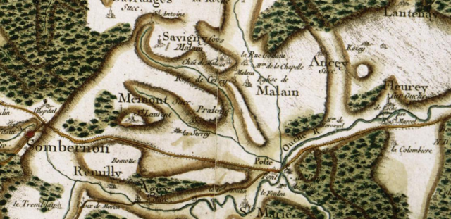
English: 18th century Cassini map; extract showing a detail of the center part of the present departement of Côte-d'Or, with Prâlon (abbey in the past), Mâlain, Mesmont, Sombernon and surroundings. The "route de Paris à Lyon par la Bourgogne" runs across the bottom of the picture.
Français : Carte de Cassini, XVIIIe siècle, détail centré sur Prâlon (ancienne abbaye), Mâlain, Mesmont, Sombernon et environs. La "route de Paris à Lyon par la Bourgogne" passe dans le bas de l'image. |
| Date | |
| Source | Carte de Cassini |
| Author | Cassini family |
| Camera location | | View this and other nearby images on: OpenStreetMap |
|---|
Licensing
edit
|
This work is in the public domain in its country of origin and other countries and areas where the copyright term is the author's life plus 70 years or fewer. This work is in the public domain in the United States because it was published (or registered with the U.S. Copyright Office) before January 1, 1929. | |
| This file has been identified as being free of known restrictions under copyright law, including all related and neighboring rights. | |
File history
Click on a date/time to view the file as it appeared at that time.
| Date/Time | Thumbnail | Dimensions | User | Comment | |
|---|---|---|---|---|---|
| current | 15:25, 17 February 2017 | | 1,115 × 542 (1.82 MB) | Pueblo89 (talk | contribs) | User created page with UploadWizard |
You cannot overwrite this file.
File usage on Commons
The following page uses this file: