File:Malta local elections 2024.svg

Size of this PNG preview of this SVG file: 533 × 500 pixels. Other resolutions: 256 × 240 pixels | 512 × 480 pixels | 819 × 768 pixels | 1,092 × 1,024 pixels | 2,183 × 2,048 pixels.
Original file (SVG file, nominally 533 × 500 pixels, file size: 209 KB)
Captions
Captions
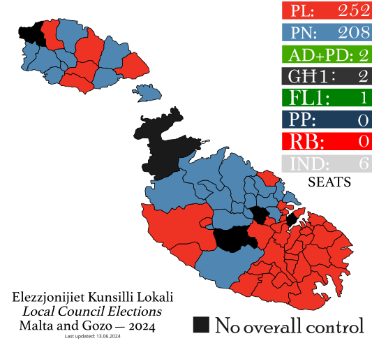
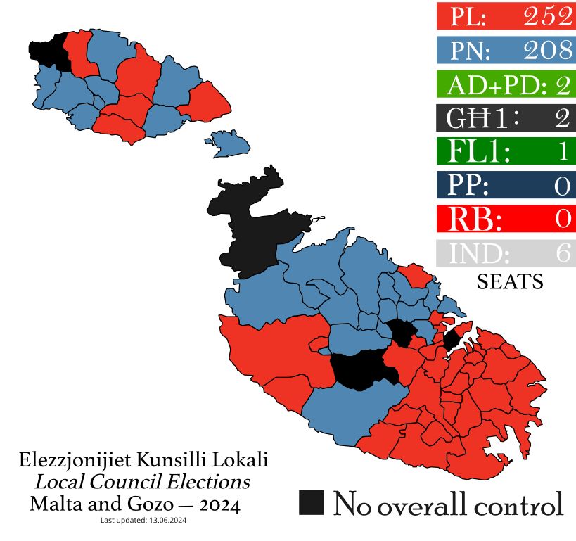
Electoral Map of Malta for the results of the upcoming 2024 Local Council elections.
Summary
edit
| Description |
English: Electoral Map of Malta divided denoting the villages, towns, and cities of Malta that have a local council. This also for the results of the upcoming 2024 Local Council elections. |
| Date | |
| Source | Own work |
| Author | Matt0513 |
Licensing
edit
I, the copyright holder of this work, hereby publish it under the following license:
This file is licensed under the Creative Commons Attribution-Share Alike 4.0 International license.
- You are free:
- to share – to copy, distribute and transmit the work
- to remix – to adapt the work
- Under the following conditions:
- attribution – You must give appropriate credit, provide a link to the license, and indicate if changes were made. You may do so in any reasonable manner, but not in any way that suggests the licensor endorses you or your use.
- share alike – If you remix, transform, or build upon the material, you must distribute your contributions under the same or compatible license as the original.
File history
Click on a date/time to view the file as it appeared at that time.
| Date/Time | Thumbnail | Dimensions | User | Comment | |
|---|---|---|---|---|---|
| current | 06:17, 15 June 2024 | | 533 × 500 (209 KB) | Matt0513 (talk | contribs) | Updated with all localities counted and result revealed. |
| 21:20, 13 June 2024 |  | 533 × 500 (212 KB) | Matt0513 (talk | contribs) | Counting in 45 of 68 villages now completed. One concluded village is not filled in this map. | |
| 21:24, 12 June 2024 |  | 533 × 500 (205 KB) | Matt0513 (talk | contribs) | Fix in Alignment and Object to Path | |
| 21:22, 12 June 2024 |  | 533 × 500 (189 KB) | Matt0513 (talk | contribs) | Filled 24 of 68 local council results. | |
| 09:25, 7 May 2024 |  | 500 × 469 (184 KB) | Matt0513 (talk | contribs) | Fixed Object to Path. For future reference: Bell MT font is used. | |
| 09:23, 7 May 2024 |  | 500 × 469 (182 KB) | Matt0513 (talk | contribs) | Changed to reflect Mdina Local Council being uncontested. | |
| 09:08, 30 April 2024 |  | 500 × 469 (181 KB) | Matt0513 (talk | contribs) | Changed to reflect *FINAL* list of candidates and parties. | |
| 10:53, 18 July 2023 |  | 500 × 469 (187 KB) | Matt0513 (talk | contribs) | Uploaded own work with UploadWizard |
You cannot overwrite this file.
File usage on Commons
The following 3 pages use this file:
File usage on other wikis
The following other wikis use this file:
- Usage on en.wikipedia.org